Masullas geodata
Masullas (Sardinia) is a seat of a third-order administrative division; located in Italy in Europe/Rome (GMT+2) time zone. With population of 1,111 people, there are 6254 cities with bigger population in this country. Compared to other cities in Italy, 89.5% of cities are located further ↑North; 84.3% of cities are located further →East and 63.9% of cities have higher elevation than Masullas. Note1


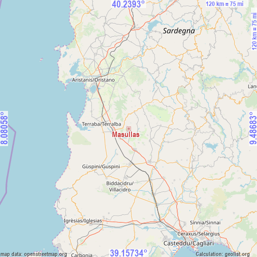
Masullas GPS coordinates[2]
39° 42' 1.584" North, 8° 47' 1.356" East
| Map corner | latitude | longitude |
|---|---|---|
| Upper-left | 40.2393°, | 8.08058° |
| Center: | 39.70044°, | 8.78371° |
| Lower-right: | 39.15734°, | 9.48683° |
| Map W x H: | 120.3×120.3 km | = 74.8×74.8mi |
| max Lat: | 47.04031° ⇑89.5% North |
| Masullas: | 39.70044° |
| min Lat: | ⇓10.5% South 35.50142° |
| min Long | Masullas | max Long |
| 6.69888° | 8.78371° | 18.48682° |
| W 15.7%⇐ | ⇒84.3% E |
Elevation
Elevation of Masullas is 135 m = 443 ft, and this is 171.7 m = 563 ft below average elevation for this country.
| Max E: |
2085 m = 6841 ft | 63.9% |
| Avg. | 306.7 m = 1006 ft | |
| Masullas | 135 m = 443 ft | |
Min E: |
-4 m = -13 ft | 36.1% |
See also: Italy elevation on elevation.city.
Geographical zone
Masullas is located in North temperate zone (between Tropic of Cancer and the Arctic Circle). Distance of this Northern Tropic circle is 1808.4 km =1123.7 mi to South.| Distance of | km | miles | from Masullas |
|---|---|---|---|
| North Pole | 5592.8 | 3475.2 | to North |
| Arctic Circle | 2986.9 | 1856 | to North |
| Tropic Cancer | 1808.4 | 1123.7 | to South |
| Equator | 4414.3 | 2742.9 | to South |


Nearby cities:
15 places around Masullas: (largest is in red/bold)
• Ales
8 km =5 mi,  19°
19°
• Baradili
10 km =6.2 mi,  76°
76°
• Baressa
7.9 km =4.9 mi, 79°
• Collinas
8.2 km =5.1 mi,  144°
144°
• Curcuris
6.5 km =4 mi,  38°
38°
• Gonnoscodina
4.5 km =2.8 mi,  91°
91°
• Gonnosnò
10.1 km =6.3 mi,  48°
48°
• Gonnostramatza
4.6 km =2.9 mi,  114°
114°
• Mogoro
1.9 km =1.2 mi,  198°
198°
• Morgongiori
5.2 km =3.2 mi,  347°
347°
• Pompu
3 km =1.9 mi, 21°
• Siddi
9.5 km =5.9 mi, 109°
• Simala
4.4 km =2.7 mi,  58°
58°
• Siris
1.5 km =0.9 mi,  330°
330°
• Uras
7 km =4.3 mi,  267°
267°
Sources, notices
• [Note1] Compared only with cities in Italy existing in our database
• [Src1] Map data: © OpenStreetMap contributors (CC-BY-SA)
• [Src2] Other city data from geonames.org with taken over terms of usage.
• [Src3] Geographical zone / Annual Mean Temperature by Robert A. Rohde @ Wikipedia
