Mogoro geodata
Mogoro (Sardinia) is a seat of a third-order administrative division; located in Italy in Europe/Rome (GMT+2) time zone. With population of 4,190 people, there are 2288 cities with bigger population in this country. Compared to other cities in Italy, 89.6% of cities are located further ↑North; 84.4% of cities are located further →East and 62.9% of cities have higher elevation than Mogoro. Note1


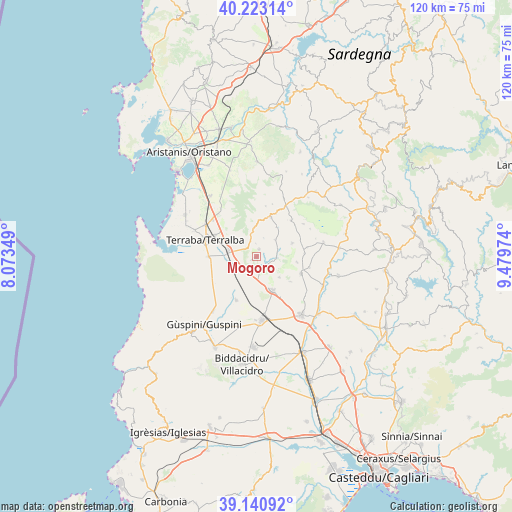
Mogoro GPS coordinates[2]
39° 41' 2.94" North, 8° 46' 35.796" East
| Map corner | latitude | longitude |
|---|---|---|
| Upper-left | 40.22314°, | 8.07349° |
| Center: | 39.68415°, | 8.77661° |
| Lower-right: | 39.14092°, | 9.47974° |
| Map W x H: | 120.3×120.3 km | = 74.8×74.8mi |
| max Lat: | 47.04031° ⇑89.6% North |
| Mogoro: | 39.68415° |
| min Lat: | ⇓10.4% South 35.50142° |
| min Long | Mogoro | max Long |
| 6.69888° | 8.77661° | 18.48682° |
| W 15.6%⇐ | ⇒84.4% E |
Elevation
Elevation of Mogoro is 142 m = 466 ft, and this is 164.7 m = 540 ft below average elevation for this country.
| Max E: |
2085 m = 6841 ft | 62.9% |
| Avg. | 306.7 m = 1006 ft | |
| Mogoro | 142 m = 466 ft | |
Min E: |
-4 m = -13 ft | 37.1% |
See also: Italy elevation on elevation.city.
Geographical zone
Mogoro is located in North temperate zone (between Tropic of Cancer and the Arctic Circle). Distance of this Northern Tropic circle is 1806.5 km =1122.5 mi to South.| Distance of | km | miles | from Mogoro |
|---|---|---|---|
| North Pole | 5594.6 | 3476.3 | to North |
| Arctic Circle | 2988.7 | 1857.1 | to North |
| Tropic Cancer | 1806.5 | 1122.5 | to South |
| Equator | 4412.5 | 2741.8 | to South |


Nearby cities:
15 places around Mogoro: (largest is in red/bold)
• Ales
9.9 km =6.2 mi,  19°
19°
• Baressa
9 km =5.6 mi,  69°
69°
• Collinas
7.2 km =4.5 mi,  131°
131°
• Curcuris
8.4 km =5.2 mi,  34°
34°
• Gonnoscodina
5.4 km =3.4 mi, 71°
• Gonnostramatza
4.8 km =3 mi,  91°
91°
• Masullas
1.9 km =1.2 mi, 18°
• Morgongiori
6.9 km =4.3 mi,  355°
355°
• Pompu
4.9 km =3 mi, 20°
• Sardara
8.6 km =5.3 mi,  153°
153°
• Siddi
9.6 km =6 mi,  97°
97°
• Simala
6 km =3.7 mi,  47°
47°
• Siris
3.1 km =1.9 mi, 357°
• Uras
6.6 km =4.1 mi,  283°
283°
• Villanovaforru
9.9 km =6.2 mi, 126°
Sources, notices
• [Note1] Compared only with cities in Italy existing in our database
• [Src1] Map data: © OpenStreetMap contributors (CC-BY-SA)
• [Src2] Other city data from geonames.org with taken over terms of usage.
• [Src3] Geographical zone / Annual Mean Temperature by Robert A. Rohde @ Wikipedia
