Serrastretta geodata
Serrastretta (Calabria) is a seat of a third-order administrative division; located in Italy in Europe/Rome (GMT+2) time zone. With population of 835 people, there are 7473 cities with bigger population in this country. Compared to other cities in Italy, 92.6% of cities are located further ↑North; 95.9% of cities are located further ←West and 93.9% of cities have lower elevation than Serrastretta. Note1


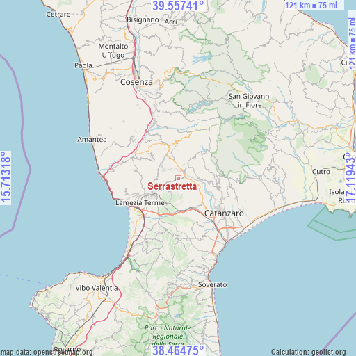
Serrastretta GPS coordinates[2]
39° 0' 47.484" North, 16° 24' 58.68" East
| Map corner | latitude | longitude |
|---|---|---|
| Upper-left | 39.55741°, | 15.71318° |
| Center: | 39.01319°, | 16.4163° |
| Lower-right: | 38.46475°, | 17.11943° |
| Map W x H: | 121.5×121.5 km | = 75.5×75.5mi |
| max Lat: | 47.04031° ⇑92.6% North |
| Serrastretta: | 39.01319° |
| min Lat: | ⇓7.4% South 35.50142° |
| min Long | Serrastretta | max Long |
| 6.69888° | 16.4163° | 18.48682° |
| W 95.9%⇐ | ⇒4.1% E |
Elevation
Elevation of Serrastretta is 836 m = 2743 ft, and this is 529.3 m = 1737 ft above average elevation for this country.
| Max E: |
2085 m = 6841 ft | 6.1% |
| Serrastretta | 836 m 2743 ft | |
| Avg. | 306.7 m = 1006 ft | |
Min E: |
-4 m = -13 ft | 93.9% |
See also: Italy elevation on elevation.city.
Geographical zone
Serrastretta is located in North temperate zone (between Tropic of Cancer and the Arctic Circle). Distance of this Northern Tropic circle is 1731.9 km =1076.2 mi to South.| Distance of | km | miles | from Serrastretta |
|---|---|---|---|
| North Pole | 5669.2 | 3522.7 | to North |
| Arctic Circle | 3063.3 | 1903.4 | to North |
| Tropic Cancer | 1731.9 | 1076.2 | to South |
| Equator | 4337.9 | 2695.4 | to South |


Nearby cities:
15 places around Serrastretta: (largest is in red/bold)
• Amato
8.9 km =5.5 mi,  153°
153°
• Cancello
8.1 km =5 mi,  171°
171°
• Carlopoli
5.6 km =3.5 mi,  36°
36°
• Castagna
5 km =3.1 mi,  20°
20°
• Cicala
6.1 km =3.8 mi,  80°
80°
• Decollatura
6.3 km =3.9 mi,  306°
306°
• Feroleto Antico
6.2 km =3.9 mi,  203°
203°
• Fronti
6.9 km =4.3 mi,  238°
238°
• Magolà
8.5 km =5.3 mi, 241°
• Miglierina
8.5 km =5.3 mi, 145°
• Panettieri
6.1 km =3.8 mi,  31°
31°
• Pianopoli
7.2 km =4.5 mi, 199°
• Platania
8.2 km =5.1 mi,  264°
264°
• San Pietro Apostolo
4.6 km =2.9 mi,  102°
102°
• Soveria Mannelli
7.9 km =4.9 mi,  334°
334°
Sources, notices
• [Note1] Compared only with cities in Italy existing in our database
• [Src1] Map data: © OpenStreetMap contributors (CC-BY-SA)
• [Src2] Other city data from geonames.org with taken over terms of usage.
• [Src3] Geographical zone / Annual Mean Temperature by Robert A. Rohde @ Wikipedia
