Magolà geodata
Magolà (Calabria) is a populated place; located in Italy in Europe/Rome (GMT+2) time zone. With population of 599 people, there are 9016 cities with bigger population in this country. Compared to other cities in Italy, 92.7% of cities are located further ↑North; 95.4% of cities are located further ←West and 66.9% of cities have lower elevation than Magolà. Note1
Administrative division(s):
- Level 1: Calabria
- Level 2: Provincia di Catanzaro
- Level 3: Lamezia Terme


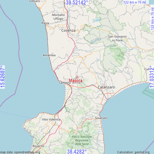
Magolà GPS coordinates[2]
38° 58' 36.912" North, 16° 19' 47.964" East
| Map corner | latitude | longitude |
|---|---|---|
| Upper-left | 39.52142°, | 15.62687° |
| Center: | 38.97692°, | 16.32999° |
| Lower-right: | 38.4282°, | 17.03312° |
| Map W x H: | 121.6×121.6 km | = 75.6×75.6mi |
| max Lat: | 47.04031° ⇑92.7% North |
| Magolà: | 38.97692° |
| min Lat: | ⇓7.3% South 35.50142° |
| min Long | Magolà | max Long |
| 6.69888° | 16.32999° | 18.48682° |
| W 95.4%⇐ | ⇒4.6% E |
Elevation
Elevation of Magolà is 362 m = 1188 ft, and this is 55.3 m = 181 ft above average elevation for this country.
| Max E: |
2085 m = 6841 ft | 33.1% |
| Magolà | 362 m 1188 ft | |
| Avg. | 306.7 m = 1006 ft | |
Min E: |
-4 m = -13 ft | 66.9% |
See also: Italy elevation on elevation.city.
Geographical zone
Magolà is located in North temperate zone (between Tropic of Cancer and the Arctic Circle). Distance of this Northern Tropic circle is 1727.9 km =1073.7 mi to South.| Distance of | km | miles | from Magolà |
|---|---|---|---|
| North Pole | 5673.2 | 3525.2 | to North |
| Arctic Circle | 3067.3 | 1905.9 | to North |
| Tropic Cancer | 1727.9 | 1073.7 | to South |
| Equator | 4333.8 | 2692.9 | to South |


Nearby cities:
15 places around Magolà: (largest is in red/bold)
• Cancello
9.5 km =5.9 mi,  114°
114°
• Conflenti
11.2 km =7 mi,  339°
339°
• Decollatura
8.1 km =5 mi,  17°
17°
• Feroleto Antico
5.3 km =3.3 mi, 107°
• Fronti
1.6 km =1 mi,  72°
72°
• Gizzeria
10.7 km =6.6 mi,  271°
271°
• Lamezia Terme
2.4 km =1.5 mi,  228°
228°
• Marinella
10.8 km =6.7 mi,  238°
238°
• Mortilla
11 km =6.8 mi,  249°
249°
• Nicastro
1.6 km =1 mi, 245°
• Pianopoli
5.8 km =3.6 mi,  118°
118°
• Platania
3.3 km =2.1 mi,  347°
347°
• Sambiase
4.2 km =2.6 mi, 254°
• Santa Eufemia Lamezia
9.2 km =5.7 mi, 226°
• Serrastretta
8.5 km =5.3 mi,  61°
61°
Sources, notices
• [Note1] Compared only with cities in Italy existing in our database
• [Src1] Map data: © OpenStreetMap contributors (CC-BY-SA)
• [Src2] Other city data from geonames.org with taken over terms of usage.
• [Src3] Geographical zone / Annual Mean Temperature by Robert A. Rohde @ Wikipedia
