San Nicola dell'Alto geodata
San Nicola dell'Alto (Calabria) is a seat of a third-order administrative division; located in Italy in Europe/Rome (GMT+2) time zone. With population of 898 people, there are 7164 cities with bigger population in this country. Compared to other cities in Italy, 91.4% of cities are located further ↑North; 97.9% of cities are located further ←West and 80.9% of cities have lower elevation than San Nicola dell'Alto. Note1
Administrative division(s):
- Level 1: Calabria
- Level 2: Provincia di Crotone
- Level 3: San Nicola dell'Alto
Current local time in San Nicola dell'Alto:
09:36 PM, WednesdayDifference from your time zone: hours


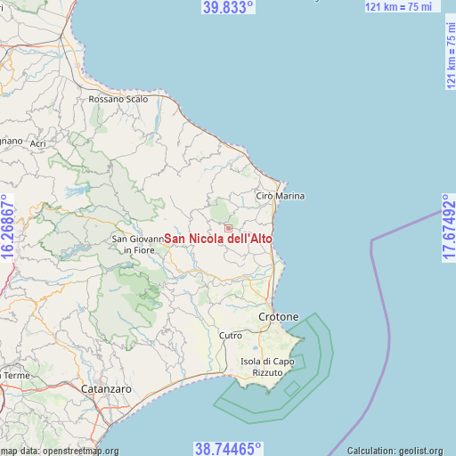
San Nicola dell'Alto GPS coordinates[2]
39° 17' 27.384" North, 16° 58' 18.444" East
| Map corner | latitude | longitude |
|---|---|---|
| Upper-left | 39.833°, | 16.26867° |
| Center: | 39.29094°, | 16.97179° |
| Lower-right: | 38.74465°, | 17.67492° |
| Map W x H: | 121×121 km | = 75.2×75.2mi |
| max Lat: | 47.04031° ⇑91.4% North |
| San Nicola dell'Alto: | 39.29094° |
| min Lat: | ⇓8.6% South 35.50142° |
| min Long | San Nicola dell | max Long |
| 6.69888° | 16.97179° | 18.48682° |
| W 97.9%⇐ | ⇒2.1% E |
Elevation
Elevation of San Nicola dell'Alto is 538 m = 1765 ft, and this is 231.3 m = 759 ft above average elevation for this country.
| Max E: |
2085 m = 6841 ft | 19.1% |
| San Nicola dell'Alto | 538 m 1765 ft | |
| Avg. | 306.7 m = 1006 ft | |
Min E: |
-4 m = -13 ft | 80.9% |
See also: Italy elevation on elevation.city.
Geographical zone
San Nicola dell'Alto is located in North temperate zone (between Tropic of Cancer and the Arctic Circle). Distance of this Northern Tropic circle is 1762.8 km =1095.4 mi to South.| Distance of | km | miles | from San Nicola dell'Alto |
|---|---|---|---|
| North Pole | 5638.3 | 3503.5 | to North |
| Arctic Circle | 3032.4 | 1884.2 | to North |
| Tropic Cancer | 1762.8 | 1095.4 | to South |
| Equator | 4368.7 | 2714.6 | to South |


Nearby cities:
15 places around San Nicola dell'Alto: (largest is in red/bold)
• Belvedere Spinello
11.6 km =7.2 mi,  216°
216°
• Carfizzi
1.9 km =1.2 mi,  7°
7°
• Casabona
4.8 km =3 mi,  197°
197°
• Cerenzia
16.6 km =10.3 mi,  252°
252°
• Cirò
12.9 km =8 mi,  37°
37°
• Cirò Marina
15.7 km =9.8 mi,  56°
56°
• Crucoli
15.4 km =9.6 mi, 9°
• Melissa
5.4 km =3.4 mi,  67°
67°
• Pallagorio
5.8 km =3.6 mi,  288°
288°
• Rocca di Neto
12.4 km =7.7 mi,  165°
165°
• Strongoli
7.6 km =4.7 mi,  111°
111°
• Torre Melissa
11.8 km =7.3 mi,  79°
79°
• Tronca
12.6 km =7.8 mi, 113°
• Umbriatico
8.3 km =5.2 mi,  326°
326°
• Verzino
10.3 km =6.4 mi,  283°
283°
Sources, notices
• [Note1] Compared only with cities in Italy existing in our database
• [Src1] Map data: © OpenStreetMap contributors (CC-BY-SA)
• [Src2] Other city data from geonames.org with taken over terms of usage.
• [Src3] Geographical zone / Annual Mean Temperature by Robert A. Rohde @ Wikipedia
