Casabona geodata
Casabona (Calabria) is a seat of a third-order administrative division; located in Italy in Europe/Rome (GMT+2) time zone. With population of 2,469 people, there are 3557 cities with bigger population in this country. Compared to other cities in Italy, 91.6% of cities are located further ↑North; 97.9% of cities are located further ←West and 56.2% of cities have lower elevation than Casabona. Note1


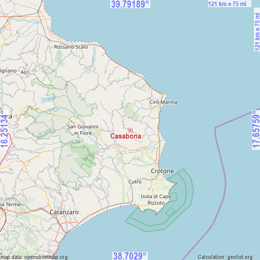
Casabona GPS coordinates[2]
39° 14' 58.236" North, 16° 57' 16.056" East
| Map corner | latitude | longitude |
|---|---|---|
| Upper-left | 39.79189°, | 16.25134° |
| Center: | 39.24951°, | 16.95446° |
| Lower-right: | 38.7029°, | 17.65759° |
| Map W x H: | 121.1×121.1 km | = 75.2×75.2mi |
| max Lat: | 47.04031° ⇑91.6% North |
| Casabona: | 39.24951° |
| min Lat: | ⇓8.4% South 35.50142° |
| min Long | Casabona | max Long |
| 6.69888° | 16.95446° | 18.48682° |
| W 97.9%⇐ | ⇒2.1% E |
Elevation
Elevation of Casabona is 273 m = 896 ft, and this is 33.7 m = 111 ft below average elevation for this country.
| Max E: |
2085 m = 6841 ft | 43.8% |
| Avg. | 306.7 m = 1006 ft | |
| Casabona | 273 m = 896 ft | |
Min E: |
-4 m = -13 ft | 56.2% |
See also: Italy elevation on elevation.city.
Geographical zone
Casabona is located in North temperate zone (between Tropic of Cancer and the Arctic Circle). Distance of this Northern Tropic circle is 1758.2 km =1092.5 mi to South.| Distance of | km | miles | from Casabona |
|---|---|---|---|
| North Pole | 5642.9 | 3506.3 | to North |
| Arctic Circle | 3037 | 1887.1 | to North |
| Tropic Cancer | 1758.2 | 1092.5 | to South |
| Equator | 4364.1 | 2711.7 | to South |


Nearby cities:
15 places around Casabona: (largest is in red/bold)
• Belvedere Spinello
7.2 km =4.5 mi,  228°
228°
• Carfizzi
6.7 km =4.2 mi,  14°
14°
• Cerenzia
14.4 km =8.9 mi,  268°
268°
• Melissa
9.3 km =5.8 mi,  44°
44°
• Pallagorio
7.6 km =4.7 mi,  328°
328°
• Rocca di Neto
8.7 km =5.4 mi,  148°
148°
• Roccabernarda
15.3 km =9.5 mi,  211°
211°
• San Nicola dell'Alto
4.8 km =3 mi,  17°
17°
• Santa Severina
11.9 km =7.4 mi,  198°
198°
• Scandale
14 km =8.7 mi,  177°
177°
• Strongoli
8.8 km =5.5 mi,  78°
78°
• Torre Melissa
14.7 km =9.1 mi,  62°
62°
• Tronca
13 km =8.1 mi,  91°
91°
• Umbriatico
12 km =7.5 mi,  344°
344°
• Verzino
11 km =6.8 mi,  309°
309°
Sources, notices
• [Note1] Compared only with cities in Italy existing in our database
• [Src1] Map data: © OpenStreetMap contributors (CC-BY-SA)
• [Src2] Other city data from geonames.org with taken over terms of usage.
• [Src3] Geographical zone / Annual Mean Temperature by Robert A. Rohde @ Wikipedia
