Cerenzia geodata
Cerenzia (Calabria) is a seat of a third-order administrative division; located in Italy in Europe/Rome (GMT+2) time zone. With population of 1,188 people, there are 5996 cities with bigger population in this country. Compared to other cities in Italy, 91.7% of cities are located further ↑North; 97.5% of cities are located further ←West and 85.7% of cities have lower elevation than Cerenzia. Note1


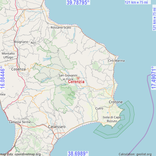
Cerenzia GPS coordinates[2]
39° 14' 43.944" North, 16° 47' 15.288" East
| Map corner | latitude | longitude |
|---|---|---|
| Upper-left | 39.78795°, | 16.08446° |
| Center: | 39.24554°, | 16.78758° |
| Lower-right: | 38.6989°, | 17.49071° |
| Map W x H: | 121.1×121.1 km | = 75.2×75.2mi |
| max Lat: | 47.04031° ⇑91.7% North |
| Cerenzia: | 39.24554° |
| min Lat: | ⇓8.3% South 35.50142° |
| min Long | Cerenzia | max Long |
| 6.69888° | 16.78758° | 18.48682° |
| W 97.5%⇐ | ⇒2.5% E |
Elevation
Elevation of Cerenzia is 625 m = 2051 ft, and this is 318.3 m = 1044 ft above average elevation for this country.
| Max E: |
2085 m = 6841 ft | 14.3% |
| Cerenzia | 625 m 2051 ft | |
| Avg. | 306.7 m = 1006 ft | |
Min E: |
-4 m = -13 ft | 85.7% |
See also: Italy elevation on elevation.city.
Geographical zone
Cerenzia is located in North temperate zone (between Tropic of Cancer and the Arctic Circle). Distance of this Northern Tropic circle is 1757.8 km =1092.2 mi to South.| Distance of | km | miles | from Cerenzia |
|---|---|---|---|
| North Pole | 5643.4 | 3506.6 | to North |
| Arctic Circle | 3037.5 | 1887.4 | to North |
| Tropic Cancer | 1757.8 | 1092.2 | to South |
| Equator | 4363.7 | 2711.5 | to South |


Nearby cities:
15 places around Cerenzia: (largest is in red/bold)
• Belvedere Spinello
10 km =6.2 mi,  115°
115°
• Caccuri
2.4 km =1.5 mi,  201°
201°
• Casabona
14.4 km =8.9 mi,  88°
88°
• Castelsilano
3.1 km =1.9 mi,  326°
326°
• Cotronei
9.6 km =6 mi,  185°
185°
• Foresta
16.4 km =10.2 mi,  172°
172°
• Pagliarelle
12.1 km =7.5 mi, 195°
• Pallagorio
12.5 km =7.8 mi,  56°
56°
• Petilia Policastro
14.8 km =9.2 mi,  181°
181°
• Roccabernarda
14 km =8.7 mi,  153°
153°
• San Giovanni in Fiore
7.9 km =4.9 mi,  277°
277°
• Santa Severina
15.2 km =9.4 mi,  135°
135°
• Savelli
7.5 km =4.7 mi,  352°
352°
• Umbriatico
16.4 km =10.2 mi,  43°
43°
• Verzino
9.6 km =6 mi, 38°
Sources, notices
• [Note1] Compared only with cities in Italy existing in our database
• [Src1] Map data: © OpenStreetMap contributors (CC-BY-SA)
• [Src2] Other city data from geonames.org with taken over terms of usage.
• [Src3] Geographical zone / Annual Mean Temperature by Robert A. Rohde @ Wikipedia
