San Floro geodata
San Floro (Calabria) is a seat of a third-order administrative division; located in Italy in Europe/Rome (GMT+2) time zone. With population of 444 people, there are 10115 cities with bigger population in this country. Compared to other cities in Italy, 93.1% of cities are located further ↑North; 96.5% of cities are located further ←West and 55.6% of cities have lower elevation than San Floro. Note1


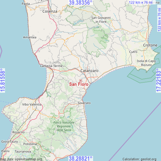
San Floro GPS coordinates[2]
38° 50' 16.764" North, 16° 31' 7.32" East
| Map corner | latitude | longitude |
|---|---|---|
| Upper-left | 39.38356°, | 15.81558° |
| Center: | 38.83799°, | 16.5187° |
| Lower-right: | 38.28821°, | 17.22183° |
| Map W x H: | 121.8×121.8 km | = 75.7×75.7mi |
| max Lat: | 47.04031° ⇑93.1% North |
| San Floro: | 38.83799° |
| min Lat: | ⇓6.9% South 35.50142° |
| min Long | San Floro | max Long |
| 6.69888° | 16.5187° | 18.48682° |
| W 96.5%⇐ | ⇒3.5% E |
Elevation
Elevation of San Floro is 269 m = 883 ft, and this is 37.7 m = 124 ft below average elevation for this country.
| Max E: |
2085 m = 6841 ft | 44.4% |
| Avg. | 306.7 m = 1006 ft | |
| San Floro | 269 m = 883 ft | |
Min E: |
-4 m = -13 ft | 55.6% |
See also: Italy elevation on elevation.city.
Geographical zone
San Floro is located in North temperate zone (between Tropic of Cancer and the Arctic Circle). Distance of this Northern Tropic circle is 1712.5 km =1064.1 mi to South.| Distance of | km | miles | from San Floro |
|---|---|---|---|
| North Pole | 5688.7 | 3534.8 | to North |
| Arctic Circle | 3082.8 | 1915.6 | to North |
| Tropic Cancer | 1712.5 | 1064.1 | to South |
| Equator | 4318.4 | 2683.3 | to South |


Nearby cities:
15 places around San Floro: (largest is in red/bold)
• Amaroni
7.8 km =4.8 mi,  231°
231°
• Borgia
1.6 km =1 mi,  216°
216°
• Caraffa di Catanzaro
5.6 km =3.5 mi,  330°
330°
• Catanzaro
8.7 km =5.4 mi,  55°
55°
• Cortale
9.5 km =5.9 mi,  271°
271°
• Germaneto
7.2 km =4.5 mi,  43°
43°
• Girifalco
8.1 km =5 mi,  260°
260°
• Martelletto
6.1 km =3.8 mi,  13°
13°
• Pratora
8.3 km =5.2 mi, 9°
• Roccelletta
7.5 km =4.7 mi,  113°
113°
• Settingiano
8.2 km =5.1 mi,  357°
357°
• Squillace
6.4 km =4 mi,  185°
185°
• Squillace Lido
8 km =5 mi,  146°
146°
• Staletti
8.4 km =5.2 mi,  167°
167°
• Vallefiorita
8.5 km =5.3 mi, 216°
Sources, notices
• [Note1] Compared only with cities in Italy existing in our database
• [Src1] Map data: © OpenStreetMap contributors (CC-BY-SA)
• [Src2] Other city data from geonames.org with taken over terms of usage.
• [Src3] Geographical zone / Annual Mean Temperature by Robert A. Rohde @ Wikipedia
