Germaneto geodata
Germaneto (Calabria) is a populated place; located in Italy in Europe/Rome (GMT+2) time zone. With population of 591 people, there are 9082 cities with bigger population in this country. Compared to other cities in Italy, 93% of cities are located further ↑North; 96.9% of cities are located further ←West and 69.7% of cities have higher elevation than Germaneto. Note1


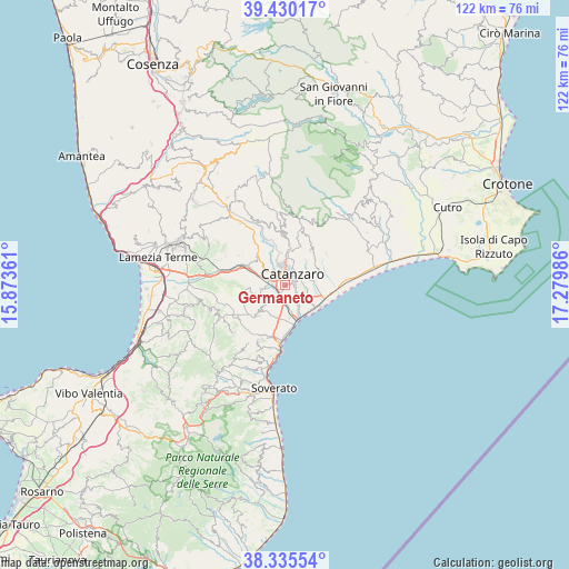
Germaneto GPS coordinates[2]
38° 53' 5.856" North, 16° 34' 36.228" East
| Map corner | latitude | longitude |
|---|---|---|
| Upper-left | 39.43017°, | 15.87361° |
| Center: | 38.88496°, | 16.57673° |
| Lower-right: | 38.33554°, | 17.27986° |
| Map W x H: | 121.7×121.7 km | = 75.6×75.6mi |
| max Lat: | 47.04031° ⇑93% North |
| Germaneto: | 38.88496° |
| min Lat: | ⇓7% South 35.50142° |
| min Long | Germaneto | max Long |
| 6.69888° | 16.57673° | 18.48682° |
| W 96.9%⇐ | ⇒3.1% E |
Elevation
Elevation of Germaneto is 99 m = 325 ft, and this is 207.7 m = 681 ft below average elevation for this country.
| Max E: |
2085 m = 6841 ft | 69.7% |
| Avg. | 306.7 m = 1006 ft | |
| Germaneto | 99 m = 325 ft | |
Min E: |
-4 m = -13 ft | 30.3% |
See also: Italy elevation on elevation.city.
Geographical zone
Germaneto is located in North temperate zone (between Tropic of Cancer and the Arctic Circle). Distance of this Northern Tropic circle is 1717.7 km =1067.3 mi to South.| Distance of | km | miles | from Germaneto |
|---|---|---|---|
| North Pole | 5683.5 | 3531.6 | to North |
| Arctic Circle | 3077.6 | 1912.3 | to North |
| Tropic Cancer | 1717.7 | 1067.3 | to South |
| Equator | 4323.6 | 2686.6 | to South |


Nearby cities:
15 places around Germaneto: (largest is in red/bold)
• Barone
6.5 km =4 mi,  123°
123°
• Borgia
8.8 km =5.5 mi,  222°
222°
• Caraffa di Catanzaro
7.8 km =4.8 mi,  267°
267°
• Catanzaro
2.1 km =1.3 mi,  97°
97°
• Cava-Cuculera Nobile
4.1 km =2.5 mi,  75°
75°
• Cavora-Lenticchia
7.7 km =4.8 mi,  347°
347°
• Marcellinara
8.9 km =5.5 mi,  300°
300°
• Martelletto
3.7 km =2.3 mi,  281°
281°
• Pratora
4.7 km =2.9 mi,  309°
309°
• Roccelletta
8.4 km =5.2 mi,  167°
167°
• San Floro
7.2 km =4.5 mi, 223°
• Sant'Elia
8.1 km =5 mi,  5°
5°
• Settingiano
6.2 km =3.9 mi, 298°
• Siano
4 km =2.5 mi,  33°
33°
• Tiriolo
8.4 km =5.2 mi,  317°
317°
Sources, notices
• [Note1] Compared only with cities in Italy existing in our database
• [Src1] Map data: © OpenStreetMap contributors (CC-BY-SA)
• [Src2] Other city data from geonames.org with taken over terms of usage.
• [Src3] Geographical zone / Annual Mean Temperature by Robert A. Rohde @ Wikipedia
