Magnano geodata
Magnano (Basilicate) is a populated place; located in Italy in Europe/Rome (GMT+2) time zone. With population of 960 people, there are 6824 cities with bigger population in this country. Compared to other cities in Italy, 87.5% of cities are located further ↑North; 93.1% of cities are located further ←West and 88.7% of cities have lower elevation than Magnano. Note1


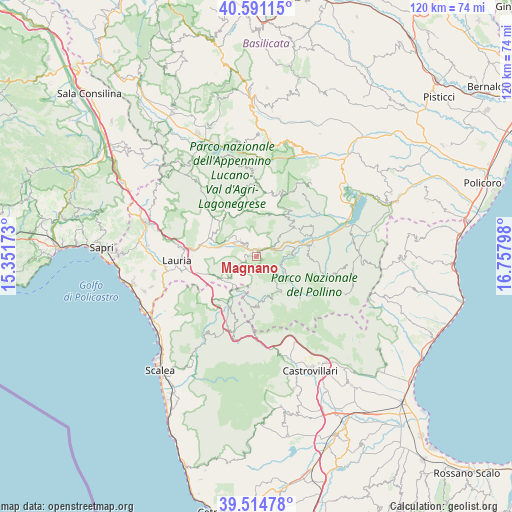
Magnano GPS coordinates[2]
40° 3' 18.324" North, 16° 3' 17.46" East
| Map corner | latitude | longitude |
|---|---|---|
| Upper-left | 40.59115°, | 15.35173° |
| Center: | 40.05509°, | 16.05485° |
| Lower-right: | 39.51478°, | 16.75798° |
| Map W x H: | 119.7×119.7 km | = 74.4×74.4mi |
| max Lat: | 47.04031° ⇑87.5% North |
| Magnano: | 40.05509° |
| min Lat: | ⇓12.5% South 35.50142° |
| min Long | Magnano | max Long |
| 6.69888° | 16.05485° | 18.48682° |
| W 93.1%⇐ | ⇒6.9% E |
Elevation
Elevation of Magnano is 686 m = 2251 ft, and this is 379.3 m = 1244 ft above average elevation for this country.
| Max E: |
2085 m = 6841 ft | 11.3% |
| Magnano | 686 m 2251 ft | |
| Avg. | 306.7 m = 1006 ft | |
Min E: |
-4 m = -13 ft | 88.7% |
See also: Italy elevation on elevation.city.
Geographical zone
Magnano is located in North temperate zone (between Tropic of Cancer and the Arctic Circle). Distance of this Northern Tropic circle is 1847.8 km =1148.2 mi to South.| Distance of | km | miles | from Magnano |
|---|---|---|---|
| North Pole | 5553.4 | 3450.7 | to North |
| Arctic Circle | 2947.5 | 1831.5 | to North |
| Tropic Cancer | 1847.8 | 1148.2 | to South |
| Equator | 4453.7 | 2767.4 | to South |


Nearby cities:
15 places around Magnano: (largest is in red/bold)
• Calvera
12.9 km =8 mi,  35°
35°
• Carbone
10.1 km =6.3 mi,  16°
16°
• Castelluccio Inferiore
8.6 km =5.3 mi,  226°
226°
• Castelluccio Superiore
8.7 km =5.4 mi, 234°
• Castelsaraceno
13 km =8.1 mi,  336°
336°
• Episcopia
4.3 km =2.7 mi,  59°
59°
• Fardella
11.8 km =7.3 mi, 56°
• Francavilla in Sinni
13 km =8.1 mi,  77°
77°
• Laino Borgo
13.2 km =8.2 mi,  211°
211°
• Latronico
5.4 km =3.4 mi,  314°
314°
• Pedali
6.7 km =4.2 mi,  176°
176°
• Rotonda
11.5 km =7.1 mi,  186°
186°
• San Severino Lucano
8.1 km =5 mi,  118°
118°
• Teana
11.5 km =7.1 mi,  46°
46°
• Viggianello
9.6 km =6 mi,  164°
164°
Sources, notices
• [Note1] Compared only with cities in Italy existing in our database
• [Src1] Map data: © OpenStreetMap contributors (CC-BY-SA)
• [Src2] Other city data from geonames.org with taken over terms of usage.
• [Src3] Geographical zone / Annual Mean Temperature by Robert A. Rohde @ Wikipedia
