Paternò geodata
Paternò (Sicily) is a seat of a third-order administrative division; located in Italy in Europe/Rome (GMT+2) time zone. With population of 46,030 people, there are 140 cities with bigger population in this country. Compared to other cities in Italy, 98.7% of cities are located further ↑North; 86.4% of cities are located further ←West and 50.7% of cities have lower elevation than Paternò. Note1


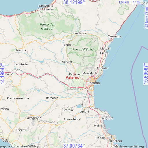
Paternò GPS coordinates[2]
37° 34' 0.3" North, 14° 54' 9.144" East
| Map corner | latitude | longitude |
|---|---|---|
| Upper-left | 38.12199°, | 14.19942° |
| Center: | 37.56675°, | 14.90254° |
| Lower-right: | 37.00734°, | 15.60567° |
| Map W x H: | 123.9×123.9 km | = 77×77mi |
| max Lat: | 47.04031° ⇑98.7% North |
| Paternò: | 37.56675° |
| min Lat: | ⇓1.3% South 35.50142° |
| min Long | Paternò | max Long |
| 6.69888° | 14.90254° | 18.48682° |
| W 86.4%⇐ | ⇒13.6% E |
Elevation
Elevation of Paternò is 239 m = 784 ft, and this is 67.7 m = 222 ft below average elevation for this country.
| Max E: |
2085 m = 6841 ft | 49.3% |
| Avg. | 306.7 m = 1006 ft | |
| Paternò | 239 m = 784 ft | |
Min E: |
-4 m = -13 ft | 50.7% |
See also: Paternò elevation on elevation.city.
Geographical zone
Paternò is located in North temperate zone (between Tropic of Cancer and the Arctic Circle). Distance of this Northern Tropic circle is 1571.1 km =976.2 mi to South.| Distance of | km | miles | from Paternò |
|---|---|---|---|
| North Pole | 5830 | 3622.6 | to North |
| Arctic Circle | 3224.1 | 2003.4 | to North |
| Tropic Cancer | 1571.1 | 976.2 | to South |
| Equator | 4177 | 2595.5 | to South |


Nearby cities:
15 places around Paternò: (largest is in red/bold)
• Adrano
12.4 km =7.7 mi,  330°
330°
• Belpasso
7.4 km =4.6 mi,  67°
67°
• Belvedere-Piano Tavola
8.6 km =5.3 mi,  118°
118°
• Biancavilla
9.2 km =5.7 mi,  339°
339°
• Camporotondo Etneo
8.9 km =5.5 mi,  90°
90°
• Gravina di Catania
14.2 km =8.8 mi, 92°
• Mascalucia
13 km =8.1 mi, 86°
• Misterbianco
10.8 km =6.7 mi, 119°
• Motta Sant'Anastasia
8.3 km =5.2 mi,  137°
137°
• Nicolosi
12.6 km =7.8 mi,  61°
61°
• Palazzolo
2.5 km =1.6 mi,  101°
101°
• Ragalna
8.5 km =5.3 mi,  27°
27°
• San Pietro Clarenza
10.6 km =6.6 mi, 88°
• Santa Maria di Licodia
5.6 km =3.5 mi,  351°
351°
• Villaggio del Pino-Le Ginestre
9.1 km =5.7 mi,  78°
78°
Sources, notices
• [Note1] Compared only with cities in Italy existing in our database
• [Src1] Map data: © OpenStreetMap contributors (CC-BY-SA)
• [Src2] Other city data from geonames.org with taken over terms of usage.
• [Src3] Geographical zone / Annual Mean Temperature by Robert A. Rohde @ Wikipedia
