Adrano geodata
Adrano (Sicily) is a seat of a third-order administrative division; located in Italy in Europe/Rome (GMT+2) time zone. With population of 34,446 people, there are 221 cities with bigger population in this country. Compared to other cities in Italy, 98.2% of cities are located further ↑North; 85.8% of cities are located further ←West and 82.4% of cities have lower elevation than Adrano. Note1


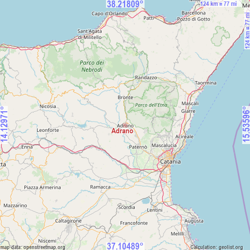
Adrano GPS coordinates[2]
37° 39' 48.888" North, 14° 49' 58.188" East
| Map corner | latitude | longitude |
|---|---|---|
| Upper-left | 38.21809°, | 14.12971° |
| Center: | 37.66358°, | 14.83283° |
| Lower-right: | 37.10489°, | 15.53596° |
| Map W x H: | 123.8×123.8 km | = 76.9×76.9mi |
| max Lat: | 47.04031° ⇑98.2% North |
| Adrano: | 37.66358° |
| min Lat: | ⇓1.8% South 35.50142° |
| min Long | Adrano | max Long |
| 6.69888° | 14.83283° | 18.48682° |
| W 85.8%⇐ | ⇒14.2% E |
Elevation
Elevation of Adrano is 562 m = 1844 ft, and this is 255.3 m = 838 ft above average elevation for this country.
| Max E: |
2085 m = 6841 ft | 17.6% |
| Adrano | 562 m 1844 ft | |
| Avg. | 306.7 m = 1006 ft | |
Min E: |
-4 m = -13 ft | 82.4% |
See also: Italy elevation on elevation.city.
Geographical zone
Adrano is located in North temperate zone (between Tropic of Cancer and the Arctic Circle). Distance of this Northern Tropic circle is 1581.9 km =982.9 mi to South.| Distance of | km | miles | from Adrano |
|---|---|---|---|
| North Pole | 5819.3 | 3615.9 | to North |
| Arctic Circle | 3213.4 | 1996.7 | to North |
| Tropic Cancer | 1581.9 | 982.9 | to South |
| Equator | 4187.8 | 2602.2 | to South |


Nearby cities:
15 places around Adrano: (largest is in red/bold)
• Belpasso
15.2 km =9.4 mi,  121°
121°
• Biancavilla
3.7 km =2.3 mi,  125°
125°
• Bronte
13.9 km =8.6 mi,  0°
0°
• Camporotondo Etneo
18.5 km =11.5 mi, 125°
• Catenanuova
16.4 km =10.2 mi,  229°
229°
• Centuripe
9.3 km =5.8 mi,  241°
241°
• Maletto
18.6 km =11.6 mi,  8°
8°
• Nicolosi
17.8 km =11.1 mi,  105°
105°
• Palazzolo
14.1 km =8.8 mi,  142°
142°
• Paternò
12.4 km =7.7 mi,  150°
150°
• Ragalna
10.6 km =6.6 mi, 107°
• Regalbuto
17.1 km =10.6 mi,  265°
265°
• San Pietro Clarenza
19.8 km =12.3 mi, 122°
• Santa Maria di Licodia
7.4 km =4.6 mi, 134°
• Villaggio del Pino-Le Ginestre
17.5 km =10.9 mi, 120°
Sources, notices
• [Note1] Compared only with cities in Italy existing in our database
• [Src1] Map data: © OpenStreetMap contributors (CC-BY-SA)
• [Src2] Other city data from geonames.org with taken over terms of usage.
• [Src3] Geographical zone / Annual Mean Temperature by Robert A. Rohde @ Wikipedia
