Belpasso geodata
Belpasso (Sicily) is a seat of a third-order administrative division; located in Italy in Europe/Rome (GMT+2) time zone. With population of 16,319 people, there are 557 cities with bigger population in this country. Compared to other cities in Italy, 98.5% of cities are located further ↑North; 87% of cities are located further ←West and 82.3% of cities have lower elevation than Belpasso. Note1


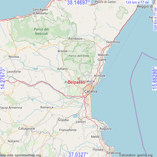
Belpasso GPS coordinates[2]
37° 35' 30.912" North, 14° 58' 47.46" East
| Map corner | latitude | longitude |
|---|---|---|
| Upper-left | 38.14697°, | 14.27673° |
| Center: | 37.59192°, | 14.97985° |
| Lower-right: | 37.0327°, | 15.68298° |
| Map W x H: | 123.9×123.9 km | = 77×77mi |
| max Lat: | 47.04031° ⇑98.5% North |
| Belpasso: | 37.59192° |
| min Lat: | ⇓1.5% South 35.50142° |
| min Long | Belpasso | max Long |
| 6.69888° | 14.97985° | 18.48682° |
| W 87%⇐ | ⇒13% E |
Elevation
Elevation of Belpasso is 559 m = 1834 ft, and this is 252.3 m = 828 ft above average elevation for this country.
| Max E: |
2085 m = 6841 ft | 17.7% |
| Belpasso | 559 m 1834 ft | |
| Avg. | 306.7 m = 1006 ft | |
Min E: |
-4 m = -13 ft | 82.3% |
See also: Italy elevation on elevation.city.
Geographical zone
Belpasso is located in North temperate zone (between Tropic of Cancer and the Arctic Circle). Distance of this Northern Tropic circle is 1573.9 km =978 mi to South.| Distance of | km | miles | from Belpasso |
|---|---|---|---|
| North Pole | 5827.2 | 3620.9 | to North |
| Arctic Circle | 3221.3 | 2001.6 | to North |
| Tropic Cancer | 1573.9 | 978 | to South |
| Equator | 4179.8 | 2597.2 | to South |


Nearby cities:
15 places around Belpasso: (largest is in red/bold)
• Belvedere-Piano Tavola
7 km =4.3 mi,  174°
174°
• Camporotondo Etneo
3.6 km =2.2 mi,  144°
144°
• Gravina di Catania
8.1 km =5 mi,  115°
115°
• Mascalucia
6.4 km =4 mi,  107°
107°
• Misterbianco
8.6 km =5.3 mi,  162°
162°
• Motta Sant'Anastasia
9 km =5.6 mi,  187°
187°
• Nicolosi
5.4 km =3.4 mi,  52°
52°
• Palazzolo
5.5 km =3.4 mi,  233°
233°
• Paternò
7.4 km =4.6 mi,  247°
247°
• Pedara
7.6 km =4.7 mi,  62°
62°
• Ragalna
5.6 km =3.5 mi,  328°
328°
• San Pietro Clarenza
4.6 km =2.9 mi, 124°
• Santa Maria di Licodia
8.1 km =5 mi,  289°
289°
• Trecastagni
9 km =5.6 mi,  73°
73°
• Villaggio del Pino-Le Ginestre
2.3 km =1.4 mi, 115°
Sources, notices
• [Note1] Compared only with cities in Italy existing in our database
• [Src1] Map data: © OpenStreetMap contributors (CC-BY-SA)
• [Src2] Other city data from geonames.org with taken over terms of usage.
• [Src3] Geographical zone / Annual Mean Temperature by Robert A. Rohde @ Wikipedia
