Ragalna geodata
Ragalna (Sicily) is a seat of a third-order administrative division; located in Italy in Europe/Rome (GMT+2) time zone. With population of 3,302 people, there are 2839 cities with bigger population in this country. Compared to other cities in Italy, 98.3% of cities are located further ↑North; 86.8% of cities are located further ←West and 92.2% of cities have lower elevation than Ragalna. Note1


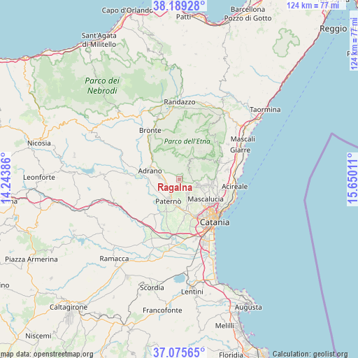
Ragalna GPS coordinates[2]
37° 38' 4.38" North, 14° 56' 49.128" East
| Map corner | latitude | longitude |
|---|---|---|
| Upper-left | 38.18928°, | 14.24386° |
| Center: | 37.63455°, | 14.94698° |
| Lower-right: | 37.07565°, | 15.65011° |
| Map W x H: | 123.8×123.8 km | = 76.9×76.9mi |
| max Lat: | 47.04031° ⇑98.3% North |
| Ragalna: | 37.63455° |
| min Lat: | ⇓1.7% South 35.50142° |
| min Long | Ragalna | max Long |
| 6.69888° | 14.94698° | 18.48682° |
| W 86.8%⇐ | ⇒13.2% E |
Elevation
Elevation of Ragalna is 778 m = 2552 ft, and this is 471.3 m = 1546 ft above average elevation for this country.
| Max E: |
2085 m = 6841 ft | 7.8% |
| Ragalna | 778 m 2552 ft | |
| Avg. | 306.7 m = 1006 ft | |
Min E: |
-4 m = -13 ft | 92.2% |
See also: Italy elevation on elevation.city.
Geographical zone
Ragalna is located in North temperate zone (between Tropic of Cancer and the Arctic Circle). Distance of this Northern Tropic circle is 1578.7 km =981 mi to South.| Distance of | km | miles | from Ragalna |
|---|---|---|---|
| North Pole | 5822.5 | 3617.9 | to North |
| Arctic Circle | 3216.6 | 1998.7 | to North |
| Tropic Cancer | 1578.7 | 981 | to South |
| Equator | 4184.6 | 2600.2 | to South |


Nearby cities:
15 places around Ragalna: (largest is in red/bold)
• Adrano
10.6 km =6.6 mi,  287°
287°
• Belpasso
5.6 km =3.5 mi,  148°
148°
• Belvedere-Piano Tavola
12.2 km =7.6 mi,  162°
162°
• Biancavilla
7.1 km =4.4 mi,  278°
278°
• Camporotondo Etneo
9.1 km =5.7 mi, 147°
• Mascalucia
11.2 km =7 mi,  126°
126°
• Monterosso
12.7 km =7.9 mi,  85°
85°
• Nicolosi
7.3 km =4.5 mi,  101°
101°
• Palazzolo
8.2 km =5.1 mi,  190°
190°
• Paternò
8.5 km =5.3 mi,  207°
207°
• Pedara
9.7 km =6 mi, 97°
• San Pietro Clarenza
9.9 km =6.2 mi,  137°
137°
• Santa Maria di Licodia
5.1 km =3.2 mi,  247°
247°
• Trecastagni
11.7 km =7.3 mi, 100°
• Villaggio del Pino-Le Ginestre
7.6 km =4.7 mi, 138°
Sources, notices
• [Note1] Compared only with cities in Italy existing in our database
• [Src1] Map data: © OpenStreetMap contributors (CC-BY-SA)
• [Src2] Other city data from geonames.org with taken over terms of usage.
• [Src3] Geographical zone / Annual Mean Temperature by Robert A. Rohde @ Wikipedia
