Papanice geodata
Papanice (Calabria) is a populated place; located in Italy in Europe/Rome (GMT+2) time zone. With population of 2,705 people, there are 3298 cities with bigger population in this country. Compared to other cities in Italy, 92.4% of cities are located further ↑North; 98% of cities are located further ←West and 61.5% of cities have higher elevation than Papanice. Note1


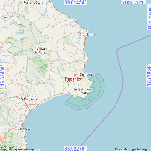
Papanice GPS coordinates[2]
39° 4' 14.772" North, 17° 1' 37.956" East
| Map corner | latitude | longitude |
|---|---|---|
| Upper-left | 39.61454°, | 16.32409° |
| Center: | 39.07077°, | 17.02721° |
| Lower-right: | 38.52278°, | 17.73034° |
| Map W x H: | 121.4×121.4 km | = 75.4×75.4mi |
| max Lat: | 47.04031° ⇑92.4% North |
| Papanice: | 39.07077° |
| min Lat: | ⇓7.6% South 35.50142° |
| min Long | Papanice | max Long |
| 6.69888° | 17.02721° | 18.48682° |
| W 98%⇐ | ⇒2% E |
Elevation
Elevation of Papanice is 152 m = 499 ft, and this is 154.7 m = 508 ft below average elevation for this country.
| Max E: |
2085 m = 6841 ft | 61.5% |
| Avg. | 306.7 m = 1006 ft | |
| Papanice | 152 m = 499 ft | |
Min E: |
-4 m = -13 ft | 38.5% |
See also: Italy elevation on elevation.city.
Geographical zone
Papanice is located in North temperate zone (between Tropic of Cancer and the Arctic Circle). Distance of this Northern Tropic circle is 1738.3 km =1080.1 mi to South.| Distance of | km | miles | from Papanice |
|---|---|---|---|
| North Pole | 5662.8 | 3518.7 | to North |
| Arctic Circle | 3056.9 | 1899.5 | to North |
| Tropic Cancer | 1738.3 | 1080.1 | to South |
| Equator | 4344.3 | 2699.4 | to South |


Nearby cities:
15 places around Papanice: (largest is in red/bold)
• Contrada Sant'Anna Iv
8.7 km =5.4 mi,  154°
154°
• Crotone
8.7 km =5.4 mi,  82°
82°
• Cutro
5.3 km =3.3 mi,  221°
221°
• Farina IV
7.9 km =4.9 mi,  114°
114°
• Foresta
18.8 km =11.7 mi,  279°
279°
• Isola di Capo Rizzuto
13.7 km =8.5 mi,  155°
155°
• Le Castella
17.9 km =11.1 mi,  181°
181°
• Marcedusa
17.2 km =10.7 mi,  253°
253°
• Rocca di Neto
12.6 km =7.8 mi,  352°
352°
• Roccabernarda
15.9 km =9.9 mi,  295°
295°
• San Leonardo di Cutro
13.8 km =8.6 mi,  196°
196°
• San Mauro Marchesato
9.6 km =6 mi,  293°
293°
• Santa Severina
13.2 km =8.2 mi,  310°
310°
• Scandale
8.1 km =5 mi,  316°
316°
• Trafinello I
7 km =4.3 mi, 105°
Sources, notices
• [Note1] Compared only with cities in Italy existing in our database
• [Src1] Map data: © OpenStreetMap contributors (CC-BY-SA)
• [Src2] Other city data from geonames.org with taken over terms of usage.
• [Src3] Geographical zone / Annual Mean Temperature by Robert A. Rohde @ Wikipedia
