San Mauro Marchesato geodata
San Mauro Marchesato (Calabria) is a seat of a third-order administrative division; located in Italy in Europe/Rome (GMT+2) time zone. With population of 2,192 people, there are 3882 cities with bigger population in this country. Compared to other cities in Italy, 92.2% of cities are located further ↑North; 97.9% of cities are located further ←West and 56% of cities have lower elevation than San Mauro Marchesato. Note1
Administrative division(s):
- Level 1: Calabria
- Level 2: Provincia di Crotone
- Level 3: San Mauro Marchesato
Current local time in San Mauro Marchesato:
08:02 PM, WednesdayDifference from your time zone: hours


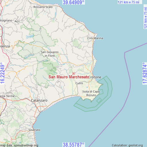
San Mauro Marchesato GPS coordinates[2]
39° 6' 20.124" North, 16° 55' 32.196" East
| Map corner | latitude | longitude |
|---|---|---|
| Upper-left | 39.64909°, | 16.22249° |
| Center: | 39.10559°, | 16.92561° |
| Lower-right: | 38.55787°, | 17.62874° |
| Map W x H: | 121.3×121.3 km | = 75.4×75.4mi |
| max Lat: | 47.04031° ⇑92.2% North |
| San Mauro Marchesato: | 39.10559° |
| min Lat: | ⇓7.8% South 35.50142° |
| min Long | San Mauro March | max Long |
| 6.69888° | 16.92561° | 18.48682° |
| W 97.9%⇐ | ⇒2.1% E |
Elevation
Elevation of San Mauro Marchesato is 272 m = 892 ft, and this is 34.7 m = 114 ft below average elevation for this country.
| Max E: |
2085 m = 6841 ft | 44% |
| Avg. | 306.7 m = 1006 ft | |
| San Mauro Marchesato | 272 m = 892 ft | |
Min E: |
-4 m = -13 ft | 56% |
See also: Italy elevation on elevation.city.
Geographical zone
San Mauro Marchesato is located in North temperate zone (between Tropic of Cancer and the Arctic Circle). Distance of this Northern Tropic circle is 1742.2 km =1082.6 mi to South.| Distance of | km | miles | from San Mauro Marchesato |
|---|---|---|---|
| North Pole | 5658.9 | 3516.3 | to North |
| Arctic Circle | 3053 | 1897 | to North |
| Tropic Cancer | 1742.2 | 1082.6 | to South |
| Equator | 4348.1 | 2701.8 | to South |


Nearby cities:
15 places around San Mauro Marchesato: (largest is in red/bold)
• Belcastro
15.5 km =9.6 mi,  230°
230°
• Belvedere Spinello
11.6 km =7.2 mi,  345°
345°
• Cotronei
14.2 km =8.8 mi,  294°
294°
• Cutro
9.5 km =5.9 mi,  146°
146°
• Foresta
9.8 km =6.1 mi,  265°
265°
• Marcedusa
11.7 km =7.3 mi,  221°
221°
• Mesoraca
12.2 km =7.6 mi,  256°
256°
• Pagliarelle
15.5 km =9.6 mi,  284°
284°
• Papanice
9.6 km =6 mi,  113°
113°
• Petilia Policastro
12.4 km =7.7 mi, 273°
• Petronà
16 km =9.9 mi,  244°
244°
• Rocca di Neto
11.1 km =6.9 mi,  39°
39°
• Roccabernarda
6.4 km =4 mi,  298°
298°
• Santa Severina
4.8 km =3 mi, 345°
• Scandale
3.7 km =2.3 mi,  57°
57°
Sources, notices
• [Note1] Compared only with cities in Italy existing in our database
• [Src1] Map data: © OpenStreetMap contributors (CC-BY-SA)
• [Src2] Other city data from geonames.org with taken over terms of usage.
• [Src3] Geographical zone / Annual Mean Temperature by Robert A. Rohde @ Wikipedia
