Goni geodata
Goni (Sardinia) is a seat of a third-order administrative division; located in Italy in Europe/Rome (GMT+2) time zone. With population of 488 people, there are 9968 cities with bigger population in this country. Compared to other cities in Italy, 90% of cities are located further ↑North; 76.6% of cities are located further →East and 69.6% of cities have lower elevation than Goni. Note1


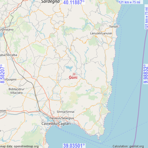
Goni GPS coordinates[2]
39° 34' 44.616" North, 9° 17' 6.684" East
| Map corner | latitude | longitude |
|---|---|---|
| Upper-left | 40.11887°, | 8.58207° |
| Center: | 39.57906°, | 9.28519° |
| Lower-right: | 39.03501°, | 9.98832° |
| Map W x H: | 120.5×120.5 km | = 74.9×74.9mi |
| max Lat: | 47.04031° ⇑90% North |
| Goni: | 39.57906° |
| min Lat: | ⇓10% South 35.50142° |
| min Long | Goni | max Long |
| 6.69888° | 9.28519° | 18.48682° |
| W 23.4%⇐ | ⇒76.6% E |
Elevation
Elevation of Goni is 390 m = 1280 ft, and this is 83.3 m = 273 ft above average elevation for this country.
| Max E: |
2085 m = 6841 ft | 30.4% |
| Goni | 390 m 1280 ft | |
| Avg. | 306.7 m = 1006 ft | |
Min E: |
-4 m = -13 ft | 69.6% |
See also: Italy elevation on elevation.city.
Geographical zone
Goni is located in North temperate zone (between Tropic of Cancer and the Arctic Circle). Distance of this Northern Tropic circle is 1794.9 km =1115.3 mi to South.| Distance of | km | miles | from Goni |
|---|---|---|---|
| North Pole | 5606.3 | 3483.6 | to North |
| Arctic Circle | 3000.4 | 1864.4 | to North |
| Tropic Cancer | 1794.9 | 1115.3 | to South |
| Equator | 4400.8 | 2734.5 | to South |


Nearby cities:
15 places around Goni: (largest is in red/bold)
• Armungia
10.4 km =6.5 mi,  128°
128°
• Ballao
7.4 km =4.6 mi,  116°
116°
• Escalaplano
7.8 km =4.8 mi,  48°
48°
• Gesico
15.8 km =9.8 mi,  285°
285°
• Nurri
15.4 km =9.6 mi,  342°
342°
• Orroli
13 km =8.1 mi,  346°
346°
• San Basilio
8.8 km =5.5 mi,  238°
238°
• San Nicolo'Gerrei
9.2 km =5.7 mi,  168°
168°
• Sant'Andrea Frius
14.9 km =9.3 mi,  221°
221°
• Selegas
15.6 km =9.7 mi,  265°
265°
• Senorbì
14.1 km =8.8 mi,  248°
248°
• Silius
6.9 km =4.3 mi, 174°
• Siurgus Donigala
8.7 km =5.4 mi, 285°
• Suelli
13.2 km =8.2 mi,  262°
262°
• Villasalto
13.2 km =8.2 mi,  137°
137°
Sources, notices
• [Note1] Compared only with cities in Italy existing in our database
• [Src1] Map data: © OpenStreetMap contributors (CC-BY-SA)
• [Src2] Other city data from geonames.org with taken over terms of usage.
• [Src3] Geographical zone / Annual Mean Temperature by Robert A. Rohde @ Wikipedia
