Uras geodata
Uras (Sardinia) is a seat of a third-order administrative division; located in Italy in Europe/Rome (GMT+2) time zone. With population of 2,787 people, there are 3227 cities with bigger population in this country. Compared to other cities in Italy, 89.5% of cities are located further ↑North; 85.5% of cities are located further →East and 86.7% of cities have higher elevation than Uras. Note1


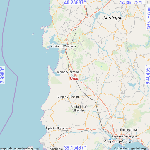
Uras GPS coordinates[2]
39° 41' 52.764" North, 8° 42' 5.148" East
| Map corner | latitude | longitude |
|---|---|---|
| Upper-left | 40.23687°, | 7.9983° |
| Center: | 39.69799°, | 8.70143° |
| Lower-right: | 39.15487°, | 9.40455° |
| Map W x H: | 120.3×120.3 km | = 74.8×74.8mi |
| max Lat: | 47.04031° ⇑89.5% North |
| Uras: | 39.69799° |
| min Lat: | ⇓10.5% South 35.50142° |
| min Long | Uras | max Long |
| 6.69888° | 8.70143° | 18.48682° |
| W 14.5%⇐ | ⇒85.5% E |
Elevation
Elevation of Uras is 26 m = 85 ft, and this is 280.7 m = 921 ft below average elevation for this country.
| Max E: |
2085 m = 6841 ft | 86.7% |
| Avg. | 306.7 m = 1006 ft | |
| Uras | 26 m = 85 ft | |
Min E: |
-4 m = -13 ft | 13.3% |
See also: Italy elevation on elevation.city.
Geographical zone
Uras is located in North temperate zone (between Tropic of Cancer and the Arctic Circle). Distance of this Northern Tropic circle is 1808.1 km =1123.5 mi to South.| Distance of | km | miles | from Uras |
|---|---|---|---|
| North Pole | 5593.1 | 3475.4 | to North |
| Arctic Circle | 2987.2 | 1856.2 | to North |
| Tropic Cancer | 1808.1 | 1123.5 | to South |
| Equator | 4414 | 2742.7 | to South |


Nearby cities:
15 places around Uras: (largest is in red/bold)
• Ales
12.5 km =7.8 mi,  51°
51°
• Curcuris
12.4 km =7.7 mi,  64°
64°
• Gonnoscodina
11.5 km =7.1 mi,  89°
89°
• Gonnostramatza
11.4 km =7.1 mi,  98°
98°
• Marrubiu
8 km =5 mi,  317°
317°
• Masullas
7 km =4.3 mi, 87°
• Mogoro
6.6 km =4.1 mi, 103°
• Morgongiori
8 km =5 mi, 47°
• Pabillonis
11.9 km =7.4 mi,  171°
171°
• Pompu
8.7 km =5.4 mi,  69°
69°
• San Nicolò d'Arcidano
5.2 km =3.2 mi,  252°
252°
• Simala
11.1 km =6.9 mi,  76°
76°
• Siris
6.5 km =4 mi, 75°
• Tanca Marchese
9.3 km =5.8 mi,  300°
300°
• Terralba
6.2 km =3.9 mi,  293°
293°
Sources, notices
• [Note1] Compared only with cities in Italy existing in our database
• [Src1] Map data: © OpenStreetMap contributors (CC-BY-SA)
• [Src2] Other city data from geonames.org with taken over terms of usage.
• [Src3] Geographical zone / Annual Mean Temperature by Robert A. Rohde @ Wikipedia
