Guamaggiore geodata
Guamaggiore (Sardinia) is a seat of a third-order administrative division; located in Italy in Europe/Rome (GMT+2) time zone. With population of 944 people, there are 6897 cities with bigger population in this country. Compared to other cities in Italy, 90% of cities are located further ↑North; 80.2% of cities are located further →East and 53.4% of cities have higher elevation than Guamaggiore. Note1
Administrative division(s):
- Level 1: Sardinia
- Level 2: Provincia del Sud Sardegna
- Level 3: Guamaggiore


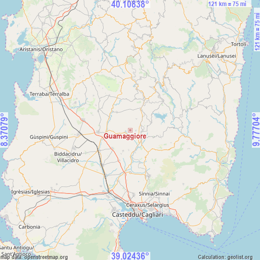
Guamaggiore GPS coordinates[2]
39° 34' 6.564" North, 9° 4' 26.076" East
| Map corner | latitude | longitude |
|---|---|---|
| Upper-left | 40.10838°, | 8.37079° |
| Center: | 39.56849°, | 9.07391° |
| Lower-right: | 39.02436°, | 9.77704° |
| Map W x H: | 120.5×120.5 km | = 74.9×74.9mi |
| max Lat: | 47.04031° ⇑90% North |
| Guamaggiore: | 39.56849° |
| min Lat: | ⇓10% South 35.50142° |
| min Long | Guamaggiore | max Long |
| 6.69888° | 9.07391° | 18.48682° |
| W 19.8%⇐ | ⇒80.2% E |
Elevation
Elevation of Guamaggiore is 214 m = 702 ft, and this is 92.7 m = 304 ft below average elevation for this country.
| Max E: |
2085 m = 6841 ft | 53.4% |
| Avg. | 306.7 m = 1006 ft | |
| Guamaggiore | 214 m = 702 ft | |
Min E: |
-4 m = -13 ft | 46.6% |
See also: Italy elevation on elevation.city.
Geographical zone
Guamaggiore is located in North temperate zone (between Tropic of Cancer and the Arctic Circle). Distance of this Northern Tropic circle is 1793.7 km =1114.6 mi to South.| Distance of | km | miles | from Guamaggiore |
|---|---|---|---|
| North Pole | 5607.5 | 3484.3 | to North |
| Arctic Circle | 3001.6 | 1865.1 | to North |
| Tropic Cancer | 1793.7 | 1114.6 | to South |
| Equator | 4399.6 | 2733.8 | to South |


Nearby cities:
15 places around Guamaggiore: (largest is in red/bold)
• Barrali
10.6 km =6.6 mi,  166°
166°
• Furtei
10.8 km =6.7 mi,  266°
266°
• Gesico
6 km =3.7 mi,  27°
27°
• Guasila
2.7 km =1.7 mi,  249°
249°
• Mandas
10.7 km =6.6 mi, 26°
• Ortacesus
3.5 km =2.2 mi,  161°
161°
• Pimentel
9.1 km =5.7 mi,  184°
184°
• Samatzai
10.1 km =6.3 mi,  199°
199°
• San Basilio
11.1 km =6.9 mi,  107°
107°
• Segariu
7.9 km =4.9 mi, 266°
• Selegas
2.5 km =1.6 mi,  91°
91°
• Senorbì
6.3 km =3.9 mi,  128°
128°
• Siurgus Donigala
10.3 km =6.4 mi,  70°
70°
• Suelli
5.1 km =3.2 mi,  97°
97°
• Villanovafranca
10.4 km =6.5 mi,  324°
324°
Sources, notices
• [Note1] Compared only with cities in Italy existing in our database
• [Src1] Map data: © OpenStreetMap contributors (CC-BY-SA)
• [Src2] Other city data from geonames.org with taken over terms of usage.
• [Src3] Geographical zone / Annual Mean Temperature by Robert A. Rohde @ Wikipedia
