Furtei geodata
Furtei (Sardinia) is a seat of a third-order administrative division; located in Italy in Europe/Rome (GMT+2) time zone. With population of 1,590 people, there are 4927 cities with bigger population in this country. Compared to other cities in Italy, 90.1% of cities are located further ↑North; 81.9% of cities are located further →East and 67.3% of cities have higher elevation than Furtei. Note1


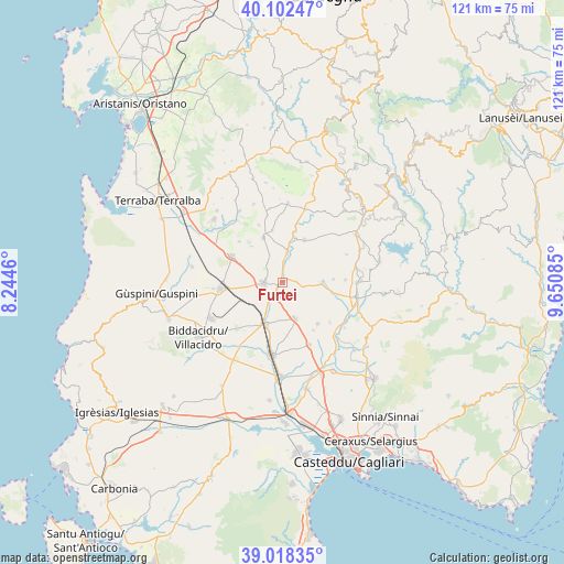
Furtei GPS coordinates[2]
39° 33' 45.108" North, 8° 56' 51.828" East
| Map corner | latitude | longitude |
|---|---|---|
| Upper-left | 40.10247°, | 8.2446° |
| Center: | 39.56253°, | 8.94773° |
| Lower-right: | 39.01835°, | 9.65085° |
| Map W x H: | 120.5×120.5 km | = 74.9×74.9mi |
| max Lat: | 47.04031° ⇑90.1% North |
| Furtei: | 39.56253° |
| min Lat: | ⇓9.9% South 35.50142° |
| min Long | Furtei | max Long |
| 6.69888° | 8.94773° | 18.48682° |
| W 18.1%⇐ | ⇒81.9% E |
Elevation
Elevation of Furtei is 114 m = 374 ft, and this is 192.7 m = 632 ft below average elevation for this country.
| Max E: |
2085 m = 6841 ft | 67.3% |
| Avg. | 306.7 m = 1006 ft | |
| Furtei | 114 m = 374 ft | |
Min E: |
-4 m = -13 ft | 32.7% |
See also: Italy elevation on elevation.city.
Geographical zone
Furtei is located in North temperate zone (between Tropic of Cancer and the Arctic Circle). Distance of this Northern Tropic circle is 1793 km =1114.1 mi to South.| Distance of | km | miles | from Furtei |
|---|---|---|---|
| North Pole | 5608.1 | 3484.7 | to North |
| Arctic Circle | 3002.2 | 1865.5 | to North |
| Tropic Cancer | 1793 | 1114.1 | to South |
| Equator | 4398.9 | 2733.3 | to South |


Nearby cities:
15 places around Furtei: (largest is in red/bold)
• Collinas
12.7 km =7.9 mi,  313°
313°
• Guamaggiore
10.8 km =6.7 mi,  86°
86°
• Guasila
8.3 km =5.2 mi, 92°
• Lunamatrona
10.5 km =6.5 mi,  336°
336°
• Ortacesus
12.2 km =7.6 mi,  102°
102°
• Pauli Arbarei
11.3 km =7 mi,  348°
348°
• Samassi
9.7 km =6 mi,  202°
202°
• Samatzai
11.6 km =7.2 mi,  139°
139°
• Sanluri
4.1 km =2.5 mi,  268°
268°
• Sardara
12.3 km =7.6 mi,  298°
298°
• Segariu
2.9 km =1.8 mi, 86°
• Serrenti
8.1 km =5 mi,  162°
162°
• Villamar
6.3 km =3.9 mi,  8°
8°
• Villanovaforru
10.2 km =6.3 mi,  319°
319°
• Villanovafranca
10.2 km =6.3 mi,  27°
27°
Sources, notices
• [Note1] Compared only with cities in Italy existing in our database
• [Src1] Map data: © OpenStreetMap contributors (CC-BY-SA)
• [Src2] Other city data from geonames.org with taken over terms of usage.
• [Src3] Geographical zone / Annual Mean Temperature by Robert A. Rohde @ Wikipedia
