Guasila geodata
Guasila (Sardinia) is a seat of a third-order administrative division; located in Italy in Europe/Rome (GMT+2) time zone. With population of 2,687 people, there are 3321 cities with bigger population in this country. Compared to other cities in Italy, 90.1% of cities are located further ↑North; 80.6% of cities are located further →East and 54.6% of cities have higher elevation than Guasila. Note1


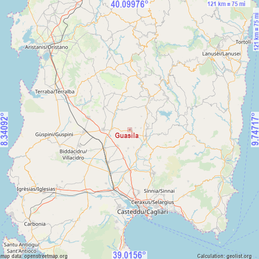
Guasila GPS coordinates[2]
39° 33' 35.28" North, 9° 2' 38.544" East
| Map corner | latitude | longitude |
|---|---|---|
| Upper-left | 40.09976°, | 8.34092° |
| Center: | 39.5598°, | 9.04404° |
| Lower-right: | 39.0156°, | 9.74717° |
| Map W x H: | 120.5×120.5 km | = 74.9×74.9mi |
| max Lat: | 47.04031° ⇑90.1% North |
| Guasila: | 39.5598° |
| min Lat: | ⇓9.9% South 35.50142° |
| min Long | Guasila | max Long |
| 6.69888° | 9.04404° | 18.48682° |
| W 19.4%⇐ | ⇒80.6% E |
Elevation
Elevation of Guasila is 205 m = 673 ft, and this is 101.7 m = 334 ft below average elevation for this country.
| Max E: |
2085 m = 6841 ft | 54.6% |
| Avg. | 306.7 m = 1006 ft | |
| Guasila | 205 m = 673 ft | |
Min E: |
-4 m = -13 ft | 45.4% |
See also: Italy elevation on elevation.city.
Geographical zone
Guasila is located in North temperate zone (between Tropic of Cancer and the Arctic Circle). Distance of this Northern Tropic circle is 1792.7 km =1113.9 mi to South.| Distance of | km | miles | from Guasila |
|---|---|---|---|
| North Pole | 5608.4 | 3484.9 | to North |
| Arctic Circle | 3002.5 | 1865.7 | to North |
| Tropic Cancer | 1792.7 | 1113.9 | to South |
| Equator | 4398.6 | 2733.2 | to South |


Nearby cities:
15 places around Guasila: (largest is in red/bold)
• Barrali
10.6 km =6.6 mi,  152°
152°
• Furtei
8.3 km =5.2 mi,  272°
272°
• Gesico
8.3 km =5.2 mi,  40°
40°
• Guamaggiore
2.7 km =1.7 mi,  69°
69°
• Ortacesus
4.3 km =2.7 mi,  122°
122°
• Pimentel
8.3 km =5.2 mi,  167°
167°
• Samatzai
8.6 km =5.3 mi,  185°
185°
• Sanluri
12.4 km =7.7 mi, 271°
• Segariu
5.4 km =3.4 mi,  275°
275°
• Selegas
5.2 km =3.2 mi,  80°
80°
• Senorbì
8.1 km =5 mi,  111°
111°
• Serrenti
9.4 km =5.8 mi,  217°
217°
• Suelli
7.6 km =4.7 mi,  87°
87°
• Villamar
9.8 km =6.1 mi,  311°
311°
• Villanovafranca
10.1 km =6.3 mi,  339°
339°
Sources, notices
• [Note1] Compared only with cities in Italy existing in our database
• [Src1] Map data: © OpenStreetMap contributors (CC-BY-SA)
• [Src2] Other city data from geonames.org with taken over terms of usage.
• [Src3] Geographical zone / Annual Mean Temperature by Robert A. Rohde @ Wikipedia
