Gela geodata
Gela (Sicily) is a seat of a third-order administrative division; located in Italy in Europe/Rome (GMT+2) time zone. With population of 73,854 people, there are 66 cities with bigger population in this country. Compared to other cities in Italy, 99.6% of cities are located further ↑North; 80.2% of cities are located further ←West and 84.4% of cities have higher elevation than Gela. Note1


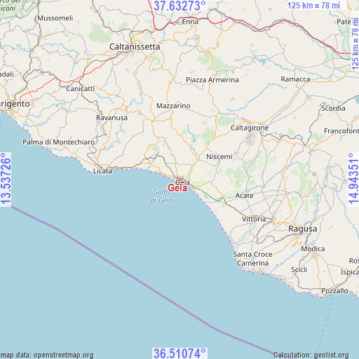
Gela GPS coordinates[2]
37° 4' 25.716" North, 14° 14' 25.368" East
| Map corner | latitude | longitude |
|---|---|---|
| Upper-left | 37.63273°, | 13.53726° |
| Center: | 37.07381°, | 14.24038° |
| Lower-right: | 36.51074°, | 14.94351° |
| Map W x H: | 124.8×124.8 km | = 77.5×77.5mi |
| max Lat: | 47.04031° ⇑99.6% North |
| Gela: | 37.07381° |
| min Lat: | ⇓0.4% South 35.50142° |
| min Long | Gela | max Long |
| 6.69888° | 14.24038° | 18.48682° |
| W 80.2%⇐ | ⇒19.8% E |
Elevation
Elevation of Gela is 33 m = 108 ft, and this is 273.7 m = 898 ft below average elevation for this country.
| Max E: |
2085 m = 6841 ft | 84.4% |
| Avg. | 306.7 m = 1006 ft | |
| Gela | 33 m = 108 ft | |
Min E: |
-4 m = -13 ft | 15.6% |
See also: Gela elevation on elevation.city.
Geographical zone
Gela is located in North temperate zone (between Tropic of Cancer and the Arctic Circle). Distance of this Northern Tropic circle is 1516.3 km =942.2 mi to South.| Distance of | km | miles | from Gela |
|---|---|---|---|
| North Pole | 5884.8 | 3656.6 | to North |
| Arctic Circle | 3279 | 2037.5 | to North |
| Tropic Cancer | 1516.3 | 942.2 | to South |
| Equator | 4122.2 | 2561.4 | to South |


Nearby cities:
15 places around Gela: (largest is in red/bold)
• Acate
23.1 km =14.4 mi,  104°
104°
• Borgo Europa
25.9 km =16.1 mi,  129°
129°
• Butera
14 km =8.7 mi,  338°
338°
• Caltagirone
30.4 km =18.9 mi,  53°
53°
• Licata
26.9 km =16.7 mi,  276°
276°
• Mazzarino
25.5 km =15.8 mi,  353°
353°
• Mazzarrone
28.5 km =17.7 mi,  86°
86°
• Niscemi
15.8 km =9.8 mi,  59°
59°
• Pedalino
30.8 km =19.1 mi, 100°
• Ravanusa
32.3 km =20.1 mi,  311°
311°
• Riesi
26.9 km =16.7 mi,  328°
328°
• San Cono
26.5 km =16.5 mi,  25°
25°
• San Michele di Ganzaria
28.3 km =17.6 mi,  35°
35°
• Scoglitti
26.3 km =16.3 mi,  139°
139°
• Vittoria
28.9 km =18 mi,  118°
118°
Sources, notices
• [Note1] Compared only with cities in Italy existing in our database
• [Src1] Map data: © OpenStreetMap contributors (CC-BY-SA)
• [Src2] Other city data from geonames.org with taken over terms of usage.
• [Src3] Geographical zone / Annual Mean Temperature by Robert A. Rohde @ Wikipedia
