Butera geodata
Butera (Sicily) is a seat of a third-order administrative division; located in Italy in Europe/Rome (GMT+2) time zone. With population of 4,683 people, there are 2072 cities with bigger population in this country. Compared to other cities in Italy, 99.5% of cities are located further ↑North; 79.6% of cities are located further ←West and 63.4% of cities have lower elevation than Butera. Note1


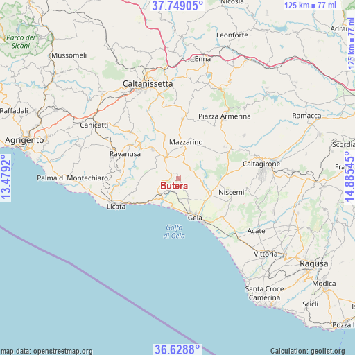
Butera GPS coordinates[2]
37° 11' 27.6" North, 14° 10' 56.352" East
| Map corner | latitude | longitude |
|---|---|---|
| Upper-left | 37.74905°, | 13.4792° |
| Center: | 37.191°, | 14.18232° |
| Lower-right: | 36.6288°, | 14.88545° |
| Map W x H: | 124.6×124.6 km | = 77.4×77.4mi |
| max Lat: | 47.04031° ⇑99.5% North |
| Butera: | 37.191° |
| min Lat: | ⇓0.5% South 35.50142° |
| min Long | Butera | max Long |
| 6.69888° | 14.18232° | 18.48682° |
| W 79.6%⇐ | ⇒20.4% E |
Elevation
Elevation of Butera is 328 m = 1076 ft, and this is 21.3 m = 70 ft above average elevation for this country.
| Max E: |
2085 m = 6841 ft | 36.6% |
| Butera | 328 m 1076 ft | |
| Avg. | 306.7 m = 1006 ft | |
Min E: |
-4 m = -13 ft | 63.4% |
See also: Italy elevation on elevation.city.
Geographical zone
Butera is located in North temperate zone (between Tropic of Cancer and the Arctic Circle). Distance of this Northern Tropic circle is 1529.3 km =950.3 mi to South.| Distance of | km | miles | from Butera |
|---|---|---|---|
| North Pole | 5871.8 | 3648.6 | to North |
| Arctic Circle | 3265.9 | 2029.3 | to North |
| Tropic Cancer | 1529.3 | 950.3 | to South |
| Equator | 4135.3 | 2569.6 | to South |


Nearby cities:
15 places around Butera: (largest is in red/bold)
• Barrafranca
20.9 km =13 mi,  4°
4°
• Campobello di Licata
24.5 km =15.2 mi,  287°
287°
• Delia
29.1 km =18.1 mi,  309°
309°
• Gela
14 km =8.7 mi,  158°
158°
• Licata
23.6 km =14.7 mi,  245°
245°
• Mazzarino
12.6 km =7.8 mi,  11°
11°
• Mirabella Imbaccari
27.8 km =17.3 mi,  57°
57°
• Niscemi
19.4 km =12.1 mi,  104°
104°
• Piazza Armerina
27.1 km =16.8 mi,  37°
37°
• Pietraperzia
25.6 km =15.9 mi,  351°
351°
• Ravanusa
20.7 km =12.9 mi, 293°
• Riesi
13.3 km =8.3 mi,  318°
318°
• San Cono
19.7 km =12.2 mi, 56°
• San Michele di Ganzaria
23.8 km =14.8 mi,  65°
65°
• Sommatino
22.9 km =14.2 mi, 314°
Sources, notices
• [Note1] Compared only with cities in Italy existing in our database
• [Src1] Map data: © OpenStreetMap contributors (CC-BY-SA)
• [Src2] Other city data from geonames.org with taken over terms of usage.
• [Src3] Geographical zone / Annual Mean Temperature by Robert A. Rohde @ Wikipedia
