Licata geodata
Licata (Sicily) is a seat of a third-order administrative division; located in Italy in Europe/Rome (GMT+2) time zone. With population of 36,537 people, there are 206 cities with bigger population in this country. Compared to other cities in Italy, 99.6% of cities are located further ↑North; 77.8% of cities are located further ←West and 92.1% of cities have higher elevation than Licata. Note1


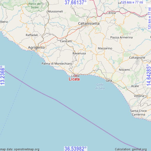
Licata GPS coordinates[2]
37° 6' 9.612" North, 13° 56' 22.992" East
| Map corner | latitude | longitude |
|---|---|---|
| Upper-left | 37.66137°, | 13.2366° |
| Center: | 37.10267°, | 13.93972° |
| Lower-right: | 36.53982°, | 14.64285° |
| Map W x H: | 124.7×124.7 km | = 77.5×77.5mi |
| max Lat: | 47.04031° ⇑99.6% North |
| Licata: | 37.10267° |
| min Lat: | ⇓0.4% South 35.50142° |
| min Long | Licata | max Long |
| 6.69888° | 13.93972° | 18.48682° |
| W 77.8%⇐ | ⇒22.2% E |
Elevation
Elevation of Licata is 14 m = 46 ft, and this is 292.7 m = 960 ft below average elevation for this country.
| Max E: |
2085 m = 6841 ft | 92.1% |
| Avg. | 306.7 m = 1006 ft | |
| Licata | 14 m = 46 ft | |
Min E: |
-4 m = -13 ft | 7.9% |
See also: Italy elevation on elevation.city.
Geographical zone
Licata is located in North temperate zone (between Tropic of Cancer and the Arctic Circle). Distance of this Northern Tropic circle is 1519.5 km =944.2 mi to South.| Distance of | km | miles | from Licata |
|---|---|---|---|
| North Pole | 5881.6 | 3654.7 | to North |
| Arctic Circle | 3275.7 | 2035.4 | to North |
| Tropic Cancer | 1519.5 | 944.2 | to South |
| Equator | 4125.4 | 2563.4 | to South |


Nearby cities:
15 places around Licata: (largest is in red/bold)
• Butera
23.6 km =14.7 mi,  65°
65°
• Camastra
21.3 km =13.2 mi,  322°
322°
• Campobello di Licata
17.3 km =10.7 mi,  353°
353°
• Canicattì
29.6 km =18.4 mi,  344°
344°
• Castrofilippo
32.3 km =20.1 mi,  328°
328°
• Delia
28.4 km =17.6 mi,  358°
358°
• Favara
34.3 km =21.3 mi,  314°
314°
• Gela
26.9 km =16.7 mi,  96°
96°
• Mazzarino
32.6 km =20.3 mi,  47°
47°
• Naro
24.8 km =15.4 mi, 328°
• Palma di Montechiaro
18.2 km =11.3 mi,  302°
302°
• Ravanusa
18.4 km =11.4 mi,  7°
7°
• Riesi
23.5 km =14.6 mi,  32°
32°
• San Leone Mosè
36.3 km =22.6 mi, 299°
• Sommatino
26.3 km =16.3 mi, 11°
Sources, notices
• [Note1] Compared only with cities in Italy existing in our database
• [Src1] Map data: © OpenStreetMap contributors (CC-BY-SA)
• [Src2] Other city data from geonames.org with taken over terms of usage.
• [Src3] Geographical zone / Annual Mean Temperature by Robert A. Rohde @ Wikipedia
