Arborea geodata
Arborea (Sardinia) is a seat of a third-order administrative division; located in Italy in Europe/Rome (GMT+2) time zone. With population of 1,896 people, there are 4323 cities with bigger population in this country. Compared to other cities in Italy, 89.2% of cities are located further ↑North; 86.9% of cities are located further →East and 94.8% of cities have higher elevation than Arborea. Note1


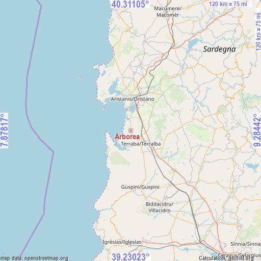
Arborea GPS coordinates[2]
39° 46' 21.936" North, 8° 34' 52.644" East
| Map corner | latitude | longitude |
|---|---|---|
| Upper-left | 40.31105°, | 7.87817° |
| Center: | 39.77276°, | 8.58129° |
| Lower-right: | 39.23023°, | 9.28442° |
| Map W x H: | 120.2×120.2 km | = 74.7×74.7mi |
| max Lat: | 47.04031° ⇑89.2% North |
| Arborea: | 39.77276° |
| min Lat: | ⇓10.8% South 35.50142° |
| min Long | Arborea | max Long |
| 6.69888° | 8.58129° | 18.48682° |
| W 13.1%⇐ | ⇒86.9% E |
Elevation
Elevation of Arborea is 9 m = 30 ft, and this is 297.7 m = 977 ft below average elevation for this country.
| Max E: |
2085 m = 6841 ft | 94.8% |
| Avg. | 306.7 m = 1006 ft | |
| Arborea | 9 m = 30 ft | |
Min E: |
-4 m = -13 ft | 5.2% |
See also: Italy elevation on elevation.city.
Geographical zone
Arborea is located in North temperate zone (between Tropic of Cancer and the Arctic Circle). Distance of this Northern Tropic circle is 1816.4 km =1128.7 mi to South.| Distance of | km | miles | from Arborea |
|---|---|---|---|
| North Pole | 5584.7 | 3470.2 | to North |
| Arctic Circle | 2978.9 | 1851 | to North |
| Tropic Cancer | 1816.4 | 1128.7 | to South |
| Equator | 4422.3 | 2747.9 | to South |


Nearby cities:
15 places around Arborea: (largest is in red/bold)
• Cabras
17.8 km =11.1 mi,  346°
346°
• Donigala Fenugheddu
18.1 km =11.2 mi,  357°
357°
• Marrubiu
5.4 km =3.4 mi,  116°
116°
• Morgongiori
16.4 km =10.2 mi,  100°
100°
• Nuraxinieddu
18.5 km =11.5 mi,  4°
4°
• Oristano
14.6 km =9.1 mi, 3°
• Palmas Arborea
12.7 km =7.9 mi,  24°
24°
• San Nicolò d'Arcidano
11.2 km =7 mi,  151°
151°
• Santa Giusta
12.2 km =7.6 mi,  11°
11°
• Silì
16.5 km =10.3 mi, 12°
• Siris
17.9 km =11.1 mi,  112°
112°
• Solanas
17.7 km =11 mi, 352°
• Tanca Marchese
4.2 km =2.6 mi, 148°
• Terralba
7.4 km =4.6 mi,  141°
141°
• Uras
13.2 km =8.2 mi,  128°
128°
Sources, notices
• [Note1] Compared only with cities in Italy existing in our database
• [Src1] Map data: © OpenStreetMap contributors (CC-BY-SA)
• [Src2] Other city data from geonames.org with taken over terms of usage.
• [Src3] Geographical zone / Annual Mean Temperature by Robert A. Rohde @ Wikipedia
