Tufara geodata
Tufara (Molise) is a seat of a third-order administrative division; located in Italy in Europe/Rome (GMT+2) time zone. With population of 845 people, there are 7424 cities with bigger population in this country. Compared to other cities in Italy, 75% of cities are located further ↑North; 86.7% of cities are located further ←West and 74.3% of cities have lower elevation than Tufara. Note1


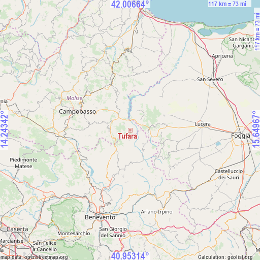
Tufara GPS coordinates[2]
41° 28' 55.308" North, 14° 56' 47.544" East
| Map corner | latitude | longitude |
|---|---|---|
| Upper-left | 42.00664°, | 14.24342° |
| Center: | 41.48203°, | 14.94654° |
| Lower-right: | 40.95314°, | 15.64967° |
| Map W x H: | 117.1×117.1 km | = 72.8×72.8mi |
| max Lat: | 47.04031° ⇑75% North |
| Tufara: | 41.48203° |
| min Lat: | ⇓25% South 35.50142° |
| min Long | Tufara | max Long |
| 6.69888° | 14.94654° | 18.48682° |
| W 86.7%⇐ | ⇒13.3% E |
Elevation
Elevation of Tufara is 443 m = 1453 ft, and this is 136.3 m = 447 ft above average elevation for this country.
| Max E: |
2085 m = 6841 ft | 25.7% |
| Tufara | 443 m 1453 ft | |
| Avg. | 306.7 m = 1006 ft | |
Min E: |
-4 m = -13 ft | 74.3% |
See also: Italy elevation on elevation.city.
Geographical zone
Tufara is located in North temperate zone (between Tropic of Cancer and the Arctic Circle). Distance of this Northern Tropic circle is 2006.5 km =1246.8 mi to South.| Distance of | km | miles | from Tufara |
|---|---|---|---|
| North Pole | 5394.7 | 3352.1 | to North |
| Arctic Circle | 2788.8 | 1732.9 | to North |
| Tropic Cancer | 2006.5 | 1246.8 | to South |
| Equator | 4612.4 | 2866 | to South |


Nearby cities:
15 places around Tufara: (largest is in red/bold)
• Baselice
10.2 km =6.3 mi,  167°
167°
• Carlantino
12.7 km =7.9 mi,  11°
11°
• Castelpagano
14.7 km =9.1 mi,  232°
232°
• Castelvetere in Val Fortore
4.4 km =2.7 mi,  185°
185°
• Celenza Valfortore
9.1 km =5.7 mi,  17°
17°
• Foiano di Val Fortore
14.6 km =9.1 mi, 170°
• Gambatesa
4.1 km =2.5 mi,  316°
316°
• Jelsi
13 km =8.1 mi,  287°
287°
• Macchia Valfortore
12.9 km =8 mi,  347°
347°
• Motta Montecorvino
14.2 km =8.8 mi,  78°
78°
• Pietracatella
12.6 km =7.8 mi,  330°
330°
• Riccia
9.6 km =6 mi,  270°
270°
• San Bartolomeo in Galdo
9.4 km =5.8 mi,  141°
141°
• San Marco la Catola
6.9 km =4.3 mi,  46°
46°
• Volturara Appula
8.9 km =5.5 mi, 79°
Sources, notices
• [Note1] Compared only with cities in Italy existing in our database
• [Src1] Map data: © OpenStreetMap contributors (CC-BY-SA)
• [Src2] Other city data from geonames.org with taken over terms of usage.
• [Src3] Geographical zone / Annual Mean Temperature by Robert A. Rohde @ Wikipedia
