Castelnuovo della Daunia geodata
Castelnuovo della Daunia (Apulia) is a seat of a third-order administrative division; located in Italy in Europe/Rome (GMT+2) time zone. With population of 1,412 people, there are 5332 cities with bigger population in this country. Compared to other cities in Italy, 74.1% of cities are located further ↑North; 88.2% of cities are located further ←West and 81.2% of cities have lower elevation than Castelnuovo della Daunia. Note1
Administrative division(s):
- Level 1: Apulia
- Level 2: Provincia di Foggia
- Level 3: Castelnuovo della Daunia
Current local time in Castelnuovo della Daunia:
07:52 PM, WednesdayDifference from your time zone: hours


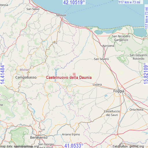
Castelnuovo della Daunia GPS coordinates[2]
41° 34' 53.004" North, 15° 7' 4.656" East
| Map corner | latitude | longitude |
|---|---|---|
| Upper-left | 42.10519°, | 14.41484° |
| Center: | 41.58139°, | 15.11796° |
| Lower-right: | 41.0533°, | 15.82109° |
| Map W x H: | 117×117 km | = 72.7×72.7mi |
| max Lat: | 47.04031° ⇑74.1% North |
| Castelnuovo della Daunia: | 41.58139° |
| min Lat: | ⇓25.9% South 35.50142° |
| min Long | Castelnuovo del | max Long |
| 6.69888° | 15.11796° | 18.48682° |
| W 88.2%⇐ | ⇒11.8% E |
Elevation
Elevation of Castelnuovo della Daunia is 542 m = 1778 ft, and this is 235.3 m = 772 ft above average elevation for this country.
| Max E: |
2085 m = 6841 ft | 18.8% |
| Castelnuovo della Daunia | 542 m 1778 ft | |
| Avg. | 306.7 m = 1006 ft | |
Min E: |
-4 m = -13 ft | 81.2% |
See also: Italy elevation on elevation.city.
Geographical zone
Castelnuovo della Daunia is located in North temperate zone (between Tropic of Cancer and the Arctic Circle). Distance of this Northern Tropic circle is 2017.5 km =1253.6 mi to South.| Distance of | km | miles | from Castelnuovo della Daunia |
|---|---|---|---|
| North Pole | 5383.6 | 3345.2 | to North |
| Arctic Circle | 2777.8 | 1726 | to North |
| Tropic Cancer | 2017.5 | 1253.6 | to South |
| Equator | 4623.4 | 2872.8 | to South |


Nearby cities:
15 places around Castelnuovo della Daunia: (largest is in red/bold)
• Alberona
16.6 km =10.3 mi,  178°
178°
• Carlantino
11.8 km =7.3 mi,  276°
276°
• Casalnuovo Monterotaro
4.4 km =2.7 mi,  344°
344°
• Casalvecchio di Puglia
1.6 km =1 mi, 335°
• Celenza Valfortore
11.8 km =7.3 mi,  258°
258°
• Colletorto
15.3 km =9.5 mi,  305°
305°
• Macchia Valfortore
17.2 km =10.7 mi, 275°
• Motta Montecorvino
8.2 km =5.1 mi, 182°
• Pietramontecorvino
4.4 km =2.7 mi,  168°
168°
• San Giuliano di Puglia
17.5 km =10.9 mi, 312°
• San Marco la Catola
11.2 km =7 mi,  235°
235°
• Santa Croce di Magliano
18.2 km =11.3 mi,  323°
323°
• Tufara
18 km =11.2 mi,  232°
232°
• Volturara Appula
11 km =6.8 mi,  209°
209°
• Volturino
11.6 km =7.2 mi, 177°
Sources, notices
• [Note1] Compared only with cities in Italy existing in our database
• [Src1] Map data: © OpenStreetMap contributors (CC-BY-SA)
• [Src2] Other city data from geonames.org with taken over terms of usage.
• [Src3] Geographical zone / Annual Mean Temperature by Robert A. Rohde @ Wikipedia
