Voltana geodata
Voltana (Emilia-Romagna) is a populated place; located in Italy in Europe/Rome (GMT+2) time zone. With population of 2,314 people, there are 3744 cities with bigger population in this country. Compared to other cities in Italy, 51.6% of cities are located further ↓South; 55% of cities are located further ←West and 96.6% of cities have higher elevation than Voltana. Note1


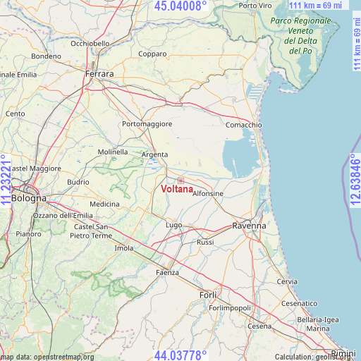
Voltana GPS coordinates[2]
44° 32' 27.924" North, 11° 56' 7.188" East
| Map corner | latitude | longitude |
|---|---|---|
| Upper-left | 45.04008°, | 11.23221° |
| Center: | 44.54109°, | 11.93533° |
| Lower-right: | 44.03778°, | 12.63846° |
| Map W x H: | 111.4×111.4 km | = 69.2×69.2mi |
| max Lat: | 47.04031° ⇑48.4% North |
| Voltana: | 44.54109° |
| min Lat: | ⇓51.6% South 35.50142° |
| min Long | Voltana | max Long |
| 6.69888° | 11.93533° | 18.48682° |
| W 55%⇐ | ⇒45% E |
Elevation
Elevation of Voltana is 6 m = 20 ft, and this is 300.7 m = 987 ft below average elevation for this country.
| Max E: |
2085 m = 6841 ft | 96.6% |
| Avg. | 306.7 m = 1006 ft | |
| Voltana | 6 m = 20 ft | |
Min E: |
-4 m = -13 ft | 3.4% |
See also: Italy elevation on elevation.city.
Geographical zone
Voltana is located in North temperate zone (between Tropic of Cancer and the Arctic Circle). Distance of this Northern Tropic circle is 2346.6 km =1458.1 mi to South.| Distance of | km | miles | from Voltana |
|---|---|---|---|
| North Pole | 5054.6 | 3140.8 | to North |
| Arctic Circle | 2448.7 | 1521.6 | to North |
| Tropic Cancer | 2346.6 | 1458.1 | to South |
| Equator | 4952.5 | 3077.3 | to South |


Nearby cities:
15 places around Voltana: (largest is in red/bold)
• Alfonsine
8.9 km =5.5 mi,  114°
114°
• Argenta
11.3 km =7 mi,  315°
315°
• Conselice
9.1 km =5.7 mi,  248°
248°
• Fusignano
8.5 km =5.3 mi,  168°
168°
• Glorie
13.7 km =8.5 mi,  125°
125°
• Lavezzola
5.2 km =3.2 mi,  295°
295°
• Longastrino
7.9 km =4.9 mi,  48°
48°
• Lugo
13.5 km =8.4 mi,  188°
188°
• Masiera
9.2 km =5.7 mi,  164°
164°
• San Bernardino
4.8 km =3 mi,  232°
232°
• San Biagio
7.3 km =4.5 mi,  314°
314°
• San Patrizio
10.3 km =6.4 mi,  238°
238°
• San Potito
12.1 km =7.5 mi,  178°
178°
• Sant'Agata sul Santerno
12.3 km =7.6 mi,  208°
208°
• Villanova
13.8 km =8.6 mi,  138°
138°
Sources, notices
• [Note1] Compared only with cities in Italy existing in our database
• [Src1] Map data: © OpenStreetMap contributors (CC-BY-SA)
• [Src2] Other city data from geonames.org with taken over terms of usage.
• [Src3] Geographical zone / Annual Mean Temperature by Robert A. Rohde @ Wikipedia
