Alfonsine geodata
Alfonsine (Emilia-Romagna) is a seat of a third-order administrative division; located in Italy in Europe/Rome (GMT+2) time zone. With population of 9,838 people, there are 963 cities with bigger population in this country. Compared to other cities in Italy, 51.2% of cities are located further ↓South; 56.4% of cities are located further ←West and 99% of cities have higher elevation than Alfonsine. Note1
Administrative division(s):
- Level 1: Emilia-Romagna
- Level 2: Provincia di Ravenna
- Level 3: Alfonsine


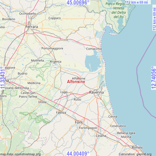
Alfonsine GPS coordinates[2]
44° 30' 27.648" North, 12° 2' 14.748" East
| Map corner | latitude | longitude |
|---|---|---|
| Upper-left | 45.00696°, | 11.33431° |
| Center: | 44.50768°, | 12.03743° |
| Lower-right: | 44.00409°, | 12.74056° |
| Map W x H: | 111.5×111.5 km | = 69.3×69.3mi |
| max Lat: | 47.04031° ⇑48.8% North |
| Alfonsine: | 44.50768° |
| min Lat: | ⇓51.2% South 35.50142° |
| min Long | Alfonsine | max Long |
| 6.69888° | 12.03743° | 18.48682° |
| W 56.4%⇐ | ⇒43.6% E |
Elevation
Elevation of Alfonsine is 2 m = 7 ft, and this is 304.7 m = 1000 ft below average elevation for this country.
| Max E: |
2085 m = 6841 ft | 99% |
| Avg. | 306.7 m = 1006 ft | |
| Alfonsine | 2 m = 7 ft | |
Min E: |
-4 m = -13 ft | 1% |
See also: Italy elevation on elevation.city.
Geographical zone
Alfonsine is located in North temperate zone (between Tropic of Cancer and the Arctic Circle). Distance of this Northern Tropic circle is 2342.9 km =1455.8 mi to South.| Distance of | km | miles | from Alfonsine |
|---|---|---|---|
| North Pole | 5058.3 | 3143.1 | to North |
| Arctic Circle | 2452.4 | 1523.9 | to North |
| Tropic Cancer | 2342.9 | 1455.8 | to South |
| Equator | 4948.8 | 3075 | to South |


Nearby cities:
15 places around Alfonsine: (largest is in red/bold)
• Alfonsine
6.6 km =4.1 mi,  149°
149°
• Bagnacavallo
11.4 km =7.1 mi,  204°
204°
• Camerlona
9.6 km =6 mi,  134°
134°
• Fusignano
7.9 km =4.9 mi,  234°
234°
• Glorie
5.2 km =3.2 mi,  143°
143°
• Longastrino
9.2 km =5.7 mi,  346°
346°
• Masiera
7.6 km =4.7 mi, 227°
• Mezzano
6 km =3.7 mi, 139°
• Piangipane
10.4 km =6.5 mi,  156°
156°
• San Potito
11.4 km =7.1 mi,  222°
222°
• Sant'Alberto
10.4 km =6.5 mi,  71°
71°
• Santerno
8 km =5 mi,  169°
169°
• Savarna-Conventello
5.5 km =3.4 mi,  90°
90°
• Villanova
6.7 km =4.2 mi, 171°
• Voltana
8.9 km =5.5 mi,  294°
294°
Sources, notices
• [Note1] Compared only with cities in Italy existing in our database
• [Src1] Map data: © OpenStreetMap contributors (CC-BY-SA)
• [Src2] Other city data from geonames.org with taken over terms of usage.
• [Src3] Geographical zone / Annual Mean Temperature by Robert A. Rohde @ Wikipedia
