Argenta geodata
Argenta (Emilia-Romagna) is a seat of a third-order administrative division; located in Italy in Europe/Rome (GMT+2) time zone. With population of 7,064 people, there are 1386 cities with bigger population in this country. Compared to other cities in Italy, 52.7% of cities are located further ↓South; 53.7% of cities are located further ←West and 95.9% of cities have higher elevation than Argenta. Note1


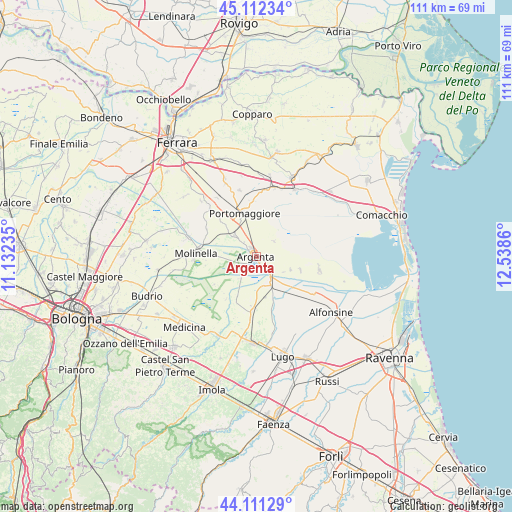
Argenta GPS coordinates[2]
44° 36' 50.292" North, 11° 50' 7.692" East
| Map corner | latitude | longitude |
|---|---|---|
| Upper-left | 45.11234°, | 11.13235° |
| Center: | 44.61397°, | 11.83547° |
| Lower-right: | 44.11129°, | 12.5386° |
| Map W x H: | 111.3×111.3 km | = 69.2×69.2mi |
| max Lat: | 47.04031° ⇑47.3% North |
| Argenta: | 44.61397° |
| min Lat: | ⇓52.7% South 35.50142° |
| min Long | Argenta | max Long |
| 6.69888° | 11.83547° | 18.48682° |
| W 53.7%⇐ | ⇒46.3% E |
Elevation
Elevation of Argenta is 7 m = 23 ft, and this is 299.7 m = 983 ft below average elevation for this country.
| Max E: |
2085 m = 6841 ft | 95.9% |
| Avg. | 306.7 m = 1006 ft | |
| Argenta | 7 m = 23 ft | |
Min E: |
-4 m = -13 ft | 4.1% |
See also: Italy elevation on elevation.city.
Geographical zone
Argenta is located in North temperate zone (between Tropic of Cancer and the Arctic Circle). Distance of this Northern Tropic circle is 2354.7 km =1463.1 mi to South.| Distance of | km | miles | from Argenta |
|---|---|---|---|
| North Pole | 5046.5 | 3135.7 | to North |
| Arctic Circle | 2440.6 | 1516.5 | to North |
| Tropic Cancer | 2354.7 | 1463.1 | to South |
| Equator | 4960.6 | 3082.4 | to South |


Nearby cities:
15 places around Argenta: (largest is in red/bold)
• Consandolo
6.7 km =4.2 mi,  314°
314°
• Conselice
11.4 km =7.1 mi,  182°
182°
• Lavezzola
6.7 km =4.2 mi,  151°
151°
• Longastrino
14.1 km =8.8 mi,  101°
101°
• Marmorta
9.5 km =5.9 mi,  272°
272°
• Molinella
13.3 km =8.3 mi, 271°
• Ospital Monacale
12.2 km =7.6 mi,  298°
298°
• Portomaggiore
9.6 km =6 mi,  346°
346°
• Ripapersico
9.1 km =5.7 mi,  334°
334°
• San Bernardino
11.8 km =7.3 mi,  159°
159°
• San Biagio
4 km =2.5 mi,  138°
138°
• San Nicolò
14.4 km =8.9 mi,  316°
316°
• San Patrizio
13.6 km =8.5 mi, 183°
• Sant'Antonio
10.8 km =6.7 mi,  240°
240°
• Voltana
11.3 km =7 mi, 135°
Sources, notices
• [Note1] Compared only with cities in Italy existing in our database
• [Src1] Map data: © OpenStreetMap contributors (CC-BY-SA)
• [Src2] Other city data from geonames.org with taken over terms of usage.
• [Src3] Geographical zone / Annual Mean Temperature by Robert A. Rohde @ Wikipedia
