Volpara geodata
Volpara (Lombardy) is a seat of a third-order administrative division; located in Italy in Europe/Rome (GMT+2) time zone. With population of 82 people, there are 11501 cities with bigger population in this country. Compared to other cities in Italy, 59% of cities are located further ↓South; 76.4% of cities are located further →East and 65% of cities have lower elevation than Volpara. Note1


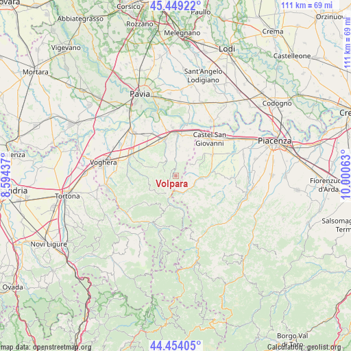
Volpara GPS coordinates[2]
44° 57' 13.644" North, 9° 17' 51" East
| Map corner | latitude | longitude |
|---|---|---|
| Upper-left | 45.44922°, | 8.59437° |
| Center: | 44.95379°, | 9.2975° |
| Lower-right: | 44.45405°, | 10.00063° |
| Map W x H: | 110.7×110.7 km | = 68.8×68.8mi |
| max Lat: | 47.04031° ⇑41% North |
| Volpara: | 44.95379° |
| min Lat: | ⇓59% South 35.50142° |
| min Long | Volpara | max Long |
| 6.69888° | 9.2975° | 18.48682° |
| W 23.6%⇐ | ⇒76.4% E |
Elevation
Elevation of Volpara is 343 m = 1125 ft, and this is 36.3 m = 119 ft above average elevation for this country.
| Max E: |
2085 m = 6841 ft | 35% |
| Volpara | 343 m 1125 ft | |
| Avg. | 306.7 m = 1006 ft | |
Min E: |
-4 m = -13 ft | 65% |
See also: Italy elevation on elevation.city.
Geographical zone
Volpara is located in North temperate zone (between Tropic of Cancer and the Arctic Circle). Distance of this Northern Tropic circle is 2392.5 km =1486.6 mi to South.| Distance of | km | miles | from Volpara |
|---|---|---|---|
| North Pole | 5008.7 | 3112.3 | to North |
| Arctic Circle | 2402.8 | 1493 | to North |
| Tropic Cancer | 2392.5 | 1486.6 | to South |
| Equator | 4998.4 | 3105.9 | to South |


Nearby cities:
15 places around Volpara: (largest is in red/bold)
• Caminata
4.9 km =3 mi,  170°
170°
• Caseo
2.1 km =1.3 mi,  237°
237°
• Castana
8.3 km =5.2 mi,  346°
346°
• Golferenzo
1 km =0.6 mi,  39°
39°
• Lirio
5.6 km =3.5 mi,  324°
324°
• Montalto Pavese
7.2 km =4.5 mi,  291°
291°
• Montecalvo Versiggia
2.2 km =1.4 mi,  334°
334°
• Nibbiano
5.9 km =3.7 mi,  155°
155°
• Pianello Val Tidone
8.5 km =5.3 mi,  95°
95°
• Pometo
3.4 km =2.1 mi,  213°
213°
• Rovescala
7 km =4.3 mi,  32°
32°
• Ruino
5 km =3.1 mi,  200°
200°
• Santa Maria della Versa
3.8 km =2.4 mi,  2°
2°
• Trevozzo
7.7 km =4.8 mi,  93°
93°
• Villa Fornace
4.1 km =2.5 mi,  299°
299°
Sources, notices
• [Note1] Compared only with cities in Italy existing in our database
• [Src1] Map data: © OpenStreetMap contributors (CC-BY-SA)
• [Src2] Other city data from geonames.org with taken over terms of usage.
• [Src3] Geographical zone / Annual Mean Temperature by Robert A. Rohde @ Wikipedia
