Nibbiano geodata
Nibbiano (Emilia-Romagna) is a seat of a third-order administrative division; located in Italy in Europe/Rome (GMT+2) time zone. With population of 418 people, there are 10207 cities with bigger population in this country. Compared to other cities in Italy, 58% of cities are located further ↓South; 75.8% of cities are located further →East and 58.7% of cities have lower elevation than Nibbiano. Note1
Administrative division(s):
- Level 1: Emilia-Romagna
- Level 2: Provincia di Piacenza
- Level 3: Alta Val Tidone


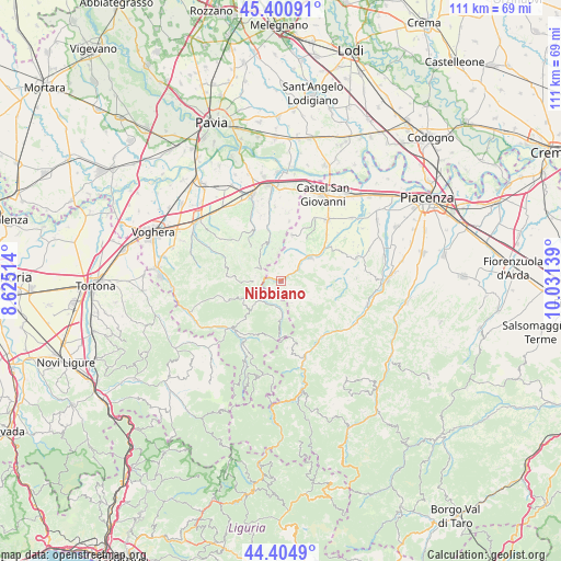
Nibbiano GPS coordinates[2]
44° 54' 18.216" North, 9° 19' 41.736" East
| Map corner | latitude | longitude |
|---|---|---|
| Upper-left | 45.40091°, | 8.62514° |
| Center: | 44.90506°, | 9.32826° |
| Lower-right: | 44.4049°, | 10.03139° |
| Map W x H: | 110.7×110.7 km | = 68.8×68.8mi |
| max Lat: | 47.04031° ⇑42% North |
| Nibbiano: | 44.90506° |
| min Lat: | ⇓58% South 35.50142° |
| min Long | Nibbiano | max Long |
| 6.69888° | 9.32826° | 18.48682° |
| W 24.2%⇐ | ⇒75.8% E |
Elevation
Elevation of Nibbiano is 290 m = 951 ft, and this is 16.7 m = 55 ft below average elevation for this country.
| Max E: |
2085 m = 6841 ft | 41.3% |
| Avg. | 306.7 m = 1006 ft | |
| Nibbiano | 290 m = 951 ft | |
Min E: |
-4 m = -13 ft | 58.7% |
See also: Italy elevation on elevation.city.
Geographical zone
Nibbiano is located in North temperate zone (between Tropic of Cancer and the Arctic Circle). Distance of this Northern Tropic circle is 2387.1 km =1483.3 mi to South.| Distance of | km | miles | from Nibbiano |
|---|---|---|---|
| North Pole | 5014.1 | 3115.6 | to North |
| Arctic Circle | 2408.2 | 1496.4 | to North |
| Tropic Cancer | 2387.1 | 1483.3 | to South |
| Equator | 4993 | 3102.5 | to South |


Nearby cities:
15 places around Nibbiano: (largest is in red/bold)
• Caminata
1.7 km =1.1 mi,  290°
290°
• Caseo
6 km =3.7 mi,  315°
315°
• Golferenzo
6.5 km =4 mi,  344°
344°
• Mombelli
8.4 km =5.2 mi,  241°
241°
• Montecalvo Versiggia
8.2 km =5.1 mi, 335°
• Pecorara
5.5 km =3.4 mi,  126°
126°
• Pianello Val Tidone
7.6 km =4.7 mi,  52°
52°
• Pometo
5 km =3.1 mi,  300°
300°
• Romagnese
7.1 km =4.4 mi,  180°
180°
• Ruino
4.2 km =2.6 mi,  279°
279°
• Santa Maria della Versa
9.4 km =5.8 mi,  346°
346°
• Trevozzo
7.3 km =4.5 mi, 46°
• Villa Fornace
9.5 km =5.9 mi, 321°
• Volpara
5.9 km =3.7 mi, 335°
• Zavattarello
6.4 km =4 mi,  229°
229°
Sources, notices
• [Note1] Compared only with cities in Italy existing in our database
• [Src1] Map data: © OpenStreetMap contributors (CC-BY-SA)
• [Src2] Other city data from geonames.org with taken over terms of usage.
• [Src3] Geographical zone / Annual Mean Temperature by Robert A. Rohde @ Wikipedia
