Pometo geodata
Pometo (Lombardy) is a seat of a third-order administrative division; located in Italy in Europe/Rome (GMT+2) time zone. With population of 270 people, there are 10803 cities with bigger population in this country. Compared to other cities in Italy, 58.4% of cities are located further ↓South; 76.9% of cities are located further →East and 79.8% of cities have lower elevation than Pometo. Note1


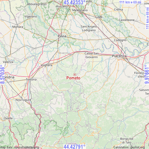
Pometo GPS coordinates[2]
44° 55' 40.368" North, 9° 16' 24.528" East
| Map corner | latitude | longitude |
|---|---|---|
| Upper-left | 45.42353°, | 8.57036° |
| Center: | 44.92788°, | 9.27348° |
| Lower-right: | 44.42791°, | 9.97661° |
| Map W x H: | 110.7×110.7 km | = 68.8×68.8mi |
| max Lat: | 47.04031° ⇑41.6% North |
| Pometo: | 44.92788° |
| min Lat: | ⇓58.4% South 35.50142° |
| min Long | Pometo | max Long |
| 6.69888° | 9.27348° | 18.48682° |
| W 23.1%⇐ | ⇒76.9% E |
Elevation
Elevation of Pometo is 522 m = 1713 ft, and this is 215.3 m = 706 ft above average elevation for this country.
| Max E: |
2085 m = 6841 ft | 20.2% |
| Pometo | 522 m 1713 ft | |
| Avg. | 306.7 m = 1006 ft | |
Min E: |
-4 m = -13 ft | 79.8% |
See also: Italy elevation on elevation.city.
Geographical zone
Pometo is located in North temperate zone (between Tropic of Cancer and the Arctic Circle). Distance of this Northern Tropic circle is 2389.6 km =1484.8 mi to South.| Distance of | km | miles | from Pometo |
|---|---|---|---|
| North Pole | 5011.5 | 3114 | to North |
| Arctic Circle | 2405.7 | 1494.8 | to North |
| Tropic Cancer | 2389.6 | 1484.8 | to South |
| Equator | 4995.5 | 3104.1 | to South |


Nearby cities:
15 places around Pometo: (largest is in red/bold)
• Borgoratto Mormorolo
6.3 km =3.9 mi,  271°
271°
• Caminata
3.4 km =2.1 mi,  125°
125°
• Caseo
1.8 km =1.1 mi,  3°
3°
• Fortunago
7 km =4.3 mi,  264°
264°
• Golferenzo
4.5 km =2.8 mi,  34°
34°
• Lirio
7.5 km =4.7 mi,  349°
349°
• Mombelli
7.3 km =4.5 mi,  205°
205°
• Montalto Pavese
7.4 km =4.6 mi,  319°
319°
• Montecalvo Versiggia
5 km =3.1 mi,  10°
10°
• Nibbiano
5 km =3.1 mi,  120°
120°
• Ruino
1.8 km =1.1 mi,  174°
174°
• Santa Maria della Versa
7 km =4.3 mi,  17°
17°
• Villa Fornace
5.2 km =3.2 mi,  341°
341°
• Volpara
3.4 km =2.1 mi, 33°
• Zavattarello
6.7 km =4.2 mi,  184°
184°
Sources, notices
• [Note1] Compared only with cities in Italy existing in our database
• [Src1] Map data: © OpenStreetMap contributors (CC-BY-SA)
• [Src2] Other city data from geonames.org with taken over terms of usage.
• [Src3] Geographical zone / Annual Mean Temperature by Robert A. Rohde @ Wikipedia
