Caminata geodata
Caminata (Emilia-Romagna) is a seat of a third-order administrative division; located in Italy in Europe/Rome (GMT+2) time zone. With population of 212 people, there are 11072 cities with bigger population in this country. Compared to other cities in Italy, 58.1% of cities are located further ↓South; 76.2% of cities are located further →East and 65.8% of cities have lower elevation than Caminata. Note1
Administrative division(s):
- Level 1: Emilia-Romagna
- Level 2: Provincia di Piacenza
- Level 3: Alta Val Tidone


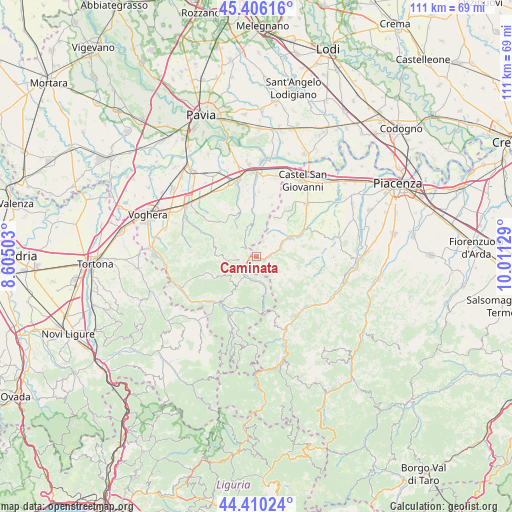
Caminata GPS coordinates[2]
44° 54' 37.296" North, 9° 18' 29.376" East
| Map corner | latitude | longitude |
|---|---|---|
| Upper-left | 45.40616°, | 8.60503° |
| Center: | 44.91036°, | 9.30816° |
| Lower-right: | 44.41024°, | 10.01129° |
| Map W x H: | 110.7×110.7 km | = 68.8×68.8mi |
| max Lat: | 47.04031° ⇑41.9% North |
| Caminata: | 44.91036° |
| min Lat: | ⇓58.1% South 35.50142° |
| min Long | Caminata | max Long |
| 6.69888° | 9.30816° | 18.48682° |
| W 23.8%⇐ | ⇒76.2% E |
Elevation
Elevation of Caminata is 351 m = 1152 ft, and this is 44.3 m = 145 ft above average elevation for this country.
| Max E: |
2085 m = 6841 ft | 34.2% |
| Caminata | 351 m 1152 ft | |
| Avg. | 306.7 m = 1006 ft | |
Min E: |
-4 m = -13 ft | 65.8% |
See also: Italy elevation on elevation.city.
Geographical zone
Caminata is located in North temperate zone (between Tropic of Cancer and the Arctic Circle). Distance of this Northern Tropic circle is 2387.6 km =1483.6 mi to South.| Distance of | km | miles | from Caminata |
|---|---|---|---|
| North Pole | 5013.5 | 3115.2 | to North |
| Arctic Circle | 2407.6 | 1496 | to North |
| Tropic Cancer | 2387.6 | 1483.6 | to South |
| Equator | 4993.6 | 3102.9 | to South |


Nearby cities:
15 places around Caminata: (largest is in red/bold)
• Caseo
4.5 km =2.8 mi,  324°
324°
• Golferenzo
5.6 km =3.5 mi,  358°
358°
• Mombelli
7.4 km =4.6 mi,  231°
231°
• Montecalvo Versiggia
7.1 km =4.4 mi,  345°
345°
• Nibbiano
1.7 km =1.1 mi,  110°
110°
• Pecorara
7.1 km =4.4 mi,  122°
122°
• Pianello Val Tidone
8.6 km =5.3 mi,  62°
62°
• Pometo
3.4 km =2.1 mi,  305°
305°
• Romagnese
7.8 km =4.8 mi,  168°
168°
• Ruino
2.6 km =1.6 mi,  272°
272°
• Santa Maria della Versa
8.6 km =5.3 mi, 355°
• Trevozzo
8.2 km =5.1 mi, 57°
• Villa Fornace
8.1 km =5 mi,  327°
327°
• Volpara
4.9 km =3 mi, 350°
• Zavattarello
5.8 km =3.6 mi,  214°
214°
Sources, notices
• [Note1] Compared only with cities in Italy existing in our database
• [Src1] Map data: © OpenStreetMap contributors (CC-BY-SA)
• [Src2] Other city data from geonames.org with taken over terms of usage.
• [Src3] Geographical zone / Annual Mean Temperature by Robert A. Rohde @ Wikipedia
