Valgreghentino geodata
Valgreghentino (Lombardy) is a seat of a third-order administrative division; located in Italy in Europe/Rome (GMT+2) time zone. With population of 3,103 people, there are 2959 cities with bigger population in this country. Compared to other cities in Italy, 84.8% of cities are located further ↓South; 74.3% of cities are located further →East and 53.6% of cities have lower elevation than Valgreghentino. Note1


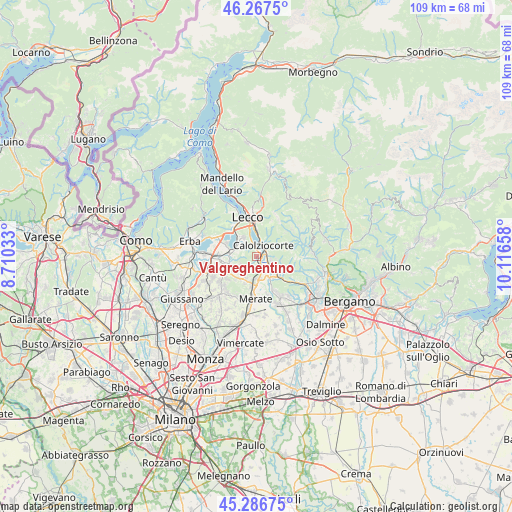
Valgreghentino GPS coordinates[2]
45° 46' 45.408" North, 9° 24' 48.42" East
| Map corner | latitude | longitude |
|---|---|---|
| Upper-left | 46.2675°, | 8.71033° |
| Center: | 45.77928°, | 9.41345° |
| Lower-right: | 45.28675°, | 10.11658° |
| Map W x H: | 109×109 km | = 67.7×67.7mi |
| max Lat: | 47.04031° ⇑15.2% North |
| Valgreghentino: | 45.77928° |
| min Lat: | ⇓84.8% South 35.50142° |
| min Long | Valgreghentino | max Long |
| 6.69888° | 9.41345° | 18.48682° |
| W 25.7%⇐ | ⇒74.3% E |
Elevation
Elevation of Valgreghentino is 257 m = 843 ft, and this is 49.7 m = 163 ft below average elevation for this country.
| Max E: |
2085 m = 6841 ft | 46.4% |
| Avg. | 306.7 m = 1006 ft | |
| Valgreghentino | 257 m = 843 ft | |
Min E: |
-4 m = -13 ft | 53.6% |
See also: Italy elevation on elevation.city.
Geographical zone
Valgreghentino is located in North temperate zone (between Tropic of Cancer and the Arctic Circle). Distance of this North polar circle is 2311 km =1436 mi to North.| Distance of | km | miles | from Valgreghentino |
|---|---|---|---|
| North Pole | 4916.9 | 3055.2 | to North |
| Arctic Circle | 2311 | 1436 | to North |
| Tropic Cancer | 2484.3 | 1543.7 | to South |
| Equator | 5090.2 | 3162.9 | to South |


Nearby cities:
15 places around Valgreghentino: (largest is in red/bold)
• Airuno
3.1 km =1.9 mi,  158°
158°
• Calolziocorte
2.6 km =1.6 mi,  46°
46°
• Carenno
4.6 km =2.9 mi,  57°
57°
• Colle Brianza
4.2 km =2.6 mi,  243°
243°
• Ello
3.8 km =2.4 mi,  280°
280°
• Favirano
3.2 km =2 mi,  84°
84°
• Galbiate
4.9 km =3 mi,  327°
327°
• Garlate
3.8 km =2.4 mi,  343°
343°
• Monte Marenzo
3.3 km =2.1 mi,  103°
103°
• Monticello-Mondonico
5.1 km =3.2 mi,  197°
197°
• Nava
4.3 km =2.7 mi, 244°
• Olginate
1.4 km =0.9 mi,  16°
16°
• Santa Maria Hoè
4.9 km =3 mi,  217°
217°
• Vercurago
3.4 km =2.1 mi,  11°
11°
• Vergano-Villa
3.4 km =2.1 mi,  298°
298°
Sources, notices
• [Note1] Compared only with cities in Italy existing in our database
• [Src1] Map data: © OpenStreetMap contributors (CC-BY-SA)
• [Src2] Other city data from geonames.org with taken over terms of usage.
• [Src3] Geographical zone / Annual Mean Temperature by Robert A. Rohde @ Wikipedia
