Villa Santa Lucia geodata
Villa Santa Lucia (Latium) is a seat of a third-order administrative division; located in Italy in Europe/Rome (GMT+2) time zone. With population of 994 people, there are 6695 cities with bigger population in this country. Compared to other cities in Italy, 74.7% of cities are located further ↑North; 76.3% of cities are located further ←West and 61.5% of cities have lower elevation than Villa Santa Lucia. Note1
Administrative division(s):
- Level 1: Latium
- Level 2: Provincia di Frosinone
- Level 3: Villa Santa Lucia


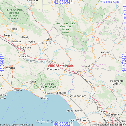
Villa Santa Lucia GPS coordinates[2]
41° 30' 43.812" North, 13° 46' 9.444" East
| Map corner | latitude | longitude |
|---|---|---|
| Upper-left | 42.03654°, | 13.06617° |
| Center: | 41.51217°, | 13.76929° |
| Lower-right: | 40.98352°, | 14.47242° |
| Map W x H: | 117.1×117.1 km | = 72.8×72.8mi |
| max Lat: | 47.04031° ⇑74.7% North |
| Villa Santa Lucia: | 41.51217° |
| min Lat: | ⇓25.3% South 35.50142° |
| min Long | Villa Santa Luc | max Long |
| 6.69888° | 13.76929° | 18.48682° |
| W 76.3%⇐ | ⇒23.7% E |
Elevation
Elevation of Villa Santa Lucia is 311 m = 1020 ft, and this is 4.3 m = 14 ft above average elevation for this country.
| Max E: |
2085 m = 6841 ft | 38.5% |
| Villa Santa Lucia | 311 m 1020 ft | |
| Avg. | 306.7 m = 1006 ft | |
Min E: |
-4 m = -13 ft | 61.5% |
See also: Italy elevation on elevation.city.
Geographical zone
Villa Santa Lucia is located in North temperate zone (between Tropic of Cancer and the Arctic Circle). Distance of this Northern Tropic circle is 2009.8 km =1248.8 mi to South.| Distance of | km | miles | from Villa Santa Lucia |
|---|---|---|---|
| North Pole | 5391.3 | 3350 | to North |
| Arctic Circle | 2785.5 | 1730.8 | to North |
| Tropic Cancer | 2009.8 | 1248.8 | to South |
| Equator | 4615.7 | 2868.1 | to South |


Nearby cities:
15 places around Villa Santa Lucia: (largest is in red/bold)
• Aquino
5.7 km =3.5 mi,  249°
249°
• Belmonte Castello
8.2 km =5.1 mi,  28°
28°
• Caira
4.6 km =2.9 mi,  59°
59°
• Cappella Morrone
8.8 km =5.5 mi,  107°
107°
• Cassino
5.7 km =3.5 mi,  120°
120°
• Castrocielo
6.3 km =3.9 mi,  285°
285°
• Colle San Magno
7.5 km =4.7 mi,  304°
304°
• Pastenelle-Pacitti-Sprumaro
9.9 km =6.2 mi, 106°
• Piedimonte San Germano
2.2 km =1.4 mi,  225°
225°
• Piedimonte San Germano Alta
1.9 km =1.2 mi,  242°
242°
• Pignataro Interamna
8.2 km =5.1 mi,  170°
170°
• Roccasecca
9.6 km =6 mi, 297°
• San Bartolomeo
8 km =5 mi, 114°
• Sant'Elia Fiumerapido
8.1 km =5 mi,  73°
73°
• Terelle
4.5 km =2.8 mi,  9°
9°
Sources, notices
• [Note1] Compared only with cities in Italy existing in our database
• [Src1] Map data: © OpenStreetMap contributors (CC-BY-SA)
• [Src2] Other city data from geonames.org with taken over terms of usage.
• [Src3] Geographical zone / Annual Mean Temperature by Robert A. Rohde @ Wikipedia
