Cassino geodata
Cassino (Latium) is a seat of a third-order administrative division; located in Italy in Europe/Rome (GMT+2) time zone. With population of 21,074 people, there are 419 cities with bigger population in this country. Compared to other cities in Italy, 74.9% of cities are located further ↑North; 76.9% of cities are located further ←West and 82.5% of cities have higher elevation than Cassino. Note1


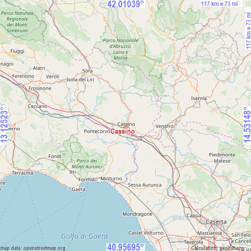
Cassino GPS coordinates[2]
41° 29' 8.916" North, 13° 49' 42.06" East
| Map corner | latitude | longitude |
|---|---|---|
| Upper-left | 42.01039°, | 13.12523° |
| Center: | 41.48581°, | 13.82835° |
| Lower-right: | 40.95695°, | 14.53148° |
| Map W x H: | 117.1×117.1 km | = 72.8×72.8mi |
| max Lat: | 47.04031° ⇑74.9% North |
| Cassino: | 41.48581° |
| min Lat: | ⇓25.1% South 35.50142° |
| min Long | Cassino | max Long |
| 6.69888° | 13.82835° | 18.48682° |
| W 76.9%⇐ | ⇒23.1% E |
Elevation
Elevation of Cassino is 40 m = 131 ft, and this is 266.7 m = 875 ft below average elevation for this country.
| Max E: |
2085 m = 6841 ft | 82.5% |
| Avg. | 306.7 m = 1006 ft | |
| Cassino | 40 m = 131 ft | |
Min E: |
-4 m = -13 ft | 17.5% |
See also: Italy elevation on elevation.city.
Geographical zone
Cassino is located in North temperate zone (between Tropic of Cancer and the Arctic Circle). Distance of this Northern Tropic circle is 2006.9 km =1247 mi to South.| Distance of | km | miles | from Cassino |
|---|---|---|---|
| North Pole | 5394.3 | 3351.9 | to North |
| Arctic Circle | 2788.4 | 1732.6 | to North |
| Tropic Cancer | 2006.9 | 1247 | to South |
| Equator | 4612.8 | 2866.3 | to South |


Nearby cities:
15 places around Cassino: (largest is in red/bold)
• Caira
5.4 km =3.4 mi,  349°
349°
• Cappella Morrone
3.5 km =2.2 mi,  84°
84°
• Cervaro
6.2 km =3.9 mi,  93°
93°
• Pastenelle-Pacitti-Sprumaro
4.6 km =2.9 mi, 88°
• Piedimonte San Germano
6.7 km =4.2 mi,  281°
281°
• Piedimonte San Germano Alta
6.9 km =4.3 mi,  287°
287°
• Pignataro Interamna
6.3 km =3.9 mi,  214°
214°
• San Bartolomeo
2.5 km =1.6 mi,  98°
98°
• San Vittore del Lazio
9.2 km =5.7 mi,  106°
106°
• Sant'Apollinare
9.3 km =5.8 mi,  179°
179°
• Sant'Elia Fiumerapido
6 km =3.7 mi,  28°
28°
• Terelle
8.5 km =5.3 mi,  330°
330°
• Vallerotonda
10.2 km =6.3 mi,  44°
44°
• Valvori
10.1 km =6.3 mi, 30°
• Villa Santa Lucia
5.7 km =3.5 mi,  300°
300°
Sources, notices
• [Note1] Compared only with cities in Italy existing in our database
• [Src1] Map data: © OpenStreetMap contributors (CC-BY-SA)
• [Src2] Other city data from geonames.org with taken over terms of usage.
• [Src3] Geographical zone / Annual Mean Temperature by Robert A. Rohde @ Wikipedia
