Castrocielo geodata
Castrocielo (Latium) is a seat of a third-order administrative division; located in Italy in Europe/Rome (GMT+2) time zone. With population of 871 people, there are 7307 cities with bigger population in this country. Compared to other cities in Italy, 74.6% of cities are located further ↑North; 75.6% of cities are located further ←West and 56.3% of cities have higher elevation than Castrocielo. Note1


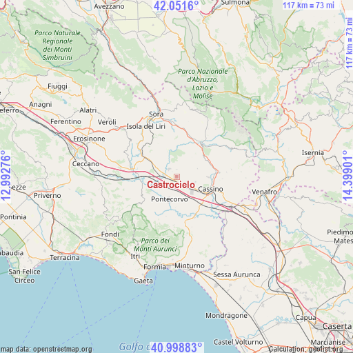
Castrocielo GPS coordinates[2]
41° 31' 38.496" North, 13° 41' 45.168" East
| Map corner | latitude | longitude |
|---|---|---|
| Upper-left | 42.0516°, | 12.99276° |
| Center: | 41.52736°, | 13.69588° |
| Lower-right: | 40.99883°, | 14.39901° |
| Map W x H: | 117.1×117.1 km | = 72.8×72.8mi |
| max Lat: | 47.04031° ⇑74.6% North |
| Castrocielo: | 41.52736° |
| min Lat: | ⇓25.4% South 35.50142° |
| min Long | Castrocielo | max Long |
| 6.69888° | 13.69588° | 18.48682° |
| W 75.6%⇐ | ⇒24.4% E |
Elevation
Elevation of Castrocielo is 193 m = 633 ft, and this is 113.7 m = 373 ft below average elevation for this country.
| Max E: |
2085 m = 6841 ft | 56.3% |
| Avg. | 306.7 m = 1006 ft | |
| Castrocielo | 193 m = 633 ft | |
Min E: |
-4 m = -13 ft | 43.7% |
See also: Italy elevation on elevation.city.
Geographical zone
Castrocielo is located in North temperate zone (between Tropic of Cancer and the Arctic Circle). Distance of this Northern Tropic circle is 2011.5 km =1249.9 mi to South.| Distance of | km | miles | from Castrocielo |
|---|---|---|---|
| North Pole | 5389.7 | 3349 | to North |
| Arctic Circle | 2783.8 | 1729.8 | to North |
| Tropic Cancer | 2011.5 | 1249.9 | to South |
| Equator | 4617.4 | 2869.1 | to South |


Nearby cities:
15 places around Castrocielo: (largest is in red/bold)
• Aquino
3.8 km =2.4 mi,  168°
168°
• Arce
10.8 km =6.7 mi,  301°
301°
• Caira
10.1 km =6.3 mi,  86°
86°
• Casalattico
10.8 km =6.7 mi,  13°
13°
• Coldragone
8.2 km =5.1 mi,  291°
291°
• Colle San Magno
2.5 km =1.6 mi,  358°
358°
• Piedimonte San Germano
5.6 km =3.5 mi,  125°
125°
• Piedimonte San Germano Alta
5.1 km =3.2 mi,  119°
119°
• Pontecorvo
8 km =5 mi,  197°
197°
• Roccasecca
3.6 km =2.2 mi,  318°
318°
• Roccasecca Stazione
3.9 km =2.4 mi,  279°
279°
• Santopadre
9.7 km =6 mi,  328°
328°
• Terelle
7.4 km =4.6 mi,  68°
68°
• Villa Felice
7.2 km =4.5 mi, 295°
• Villa Santa Lucia
6.3 km =3.9 mi,  105°
105°
Sources, notices
• [Note1] Compared only with cities in Italy existing in our database
• [Src1] Map data: © OpenStreetMap contributors (CC-BY-SA)
• [Src2] Other city data from geonames.org with taken over terms of usage.
• [Src3] Geographical zone / Annual Mean Temperature by Robert A. Rohde @ Wikipedia
