Villabassa geodata
Villabassa (Trentino-Alto Adige) is a seat of a third-order administrative division; located in Italy in Europe/Rome (GMT+2) time zone. With population of 1,390 people, there are 5387 cities with bigger population in this country. Compared to other cities in Italy, 99.4% of cities are located further ↓South; 58.2% of cities are located further ←West and 98.3% of cities have lower elevation than Villabassa. Note1


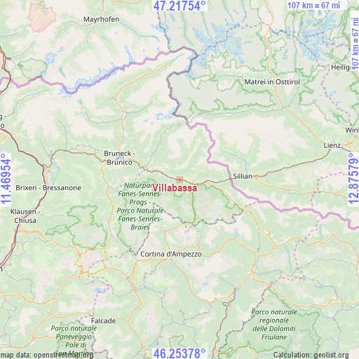
Villabassa GPS coordinates[2]
46° 44' 16.116" North, 12° 10' 21.576" East
| Map corner | latitude | longitude |
|---|---|---|
| Upper-left | 47.21754°, | 11.46954° |
| Center: | 46.73781°, | 12.17266° |
| Lower-right: | 46.25378°, | 12.87579° |
| Map W x H: | 107.2×107.2 km | = 66.6×66.6mi |
| max Lat: | 47.04031° ⇑0.6% North |
| Villabassa: | 46.73781° |
| min Lat: | ⇓99.4% South 35.50142° |
| min Long | Villabassa | max Long |
| 6.69888° | 12.17266° | 18.48682° |
| W 58.2%⇐ | ⇒41.8% E |
Elevation
Elevation of Villabassa is 1153 m = 3783 ft, and this is 846.3 m = 2777 ft above average elevation for this country.
| Max E: |
2085 m = 6841 ft | 1.7% |
| Villabassa | 1153 m 3783 ft | |
| Avg. | 306.7 m = 1006 ft | |
Min E: |
-4 m = -13 ft | 98.3% |
See also: Italy elevation on elevation.city.
Geographical zone
Villabassa is located in North temperate zone (between Tropic of Cancer and the Arctic Circle). Distance of this North polar circle is 2204.4 km =1369.8 mi to North.| Distance of | km | miles | from Villabassa |
|---|---|---|---|
| North Pole | 4810.3 | 2989 | to North |
| Arctic Circle | 2204.4 | 1369.8 | to North |
| Tropic Cancer | 2590.8 | 1609.8 | to South |
| Equator | 5196.8 | 3229.1 | to South |


Nearby cities:
15 places around Villabassa: (largest is in red/bold)
• Anterselva di Mezzo
14.5 km =9 mi,  337°
337°
• Braies
3.6 km =2.2 mi,  236°
236°
• Dobbiaco
3.9 km =2.4 mi,  104°
104°
• Monguelfo
5.6 km =3.5 mi,  293°
293°
• Perca
15.7 km =9.8 mi, 293°
• Rasun Anterselva - Rasen-Antholz
10.6 km =6.6 mi,  295°
295°
• Rasun di Sopra
10.5 km =6.5 mi, 303°
• San Candido
8.1 km =5 mi,  94°
94°
• San Giuseppe
15.7 km =9.8 mi,  109°
109°
• San Martino
9.1 km =5.7 mi,  26°
26°
• Sesto
14.1 km =8.8 mi, 106°
• Tesido
5.7 km =3.5 mi,  307°
307°
• Valdaora di Mezzo
11.2 km =7 mi,  282°
282°
• Valdaora di Sotto
12.2 km =7.6 mi, 285°
• Valle di Casies - Gsies
3.4 km =2.1 mi,  8°
8°
Sources, notices
• [Note1] Compared only with cities in Italy existing in our database
• [Src1] Map data: © OpenStreetMap contributors (CC-BY-SA)
• [Src2] Other city data from geonames.org with taken over terms of usage.
• [Src3] Geographical zone / Annual Mean Temperature by Robert A. Rohde @ Wikipedia
