San Candido geodata
San Candido (Trentino-Alto Adige) is a seat of a third-order administrative division; located in Italy in Europe/Rome (GMT+2) time zone. With population of 2,282 people, there are 3780 cities with bigger population in this country. Compared to other cities in Italy, 99.4% of cities are located further ↓South; 59.6% of cities are located further ←West and 98.5% of cities have lower elevation than San Candido. Note1
Administrative division(s):
- Level 1: Trentino-Alto Adige
- Level 2: Bolzano
- Level 3: San Candido - Innichen


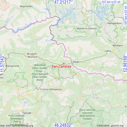
San Candido GPS coordinates[2]
46° 43' 56.64" North, 12° 16' 42.78" East
| Map corner | latitude | longitude |
|---|---|---|
| Upper-left | 47.21217°, | 11.57543° |
| Center: | 46.7324°, | 12.27855° |
| Lower-right: | 46.24832°, | 12.98168° |
| Map W x H: | 107.2×107.2 km | = 66.6×66.6mi |
| max Lat: | 47.04031° ⇑0.6% North |
| San Candido: | 46.7324° |
| min Lat: | ⇓99.4% South 35.50142° |
| min Long | San Candido | max Long |
| 6.69888° | 12.27855° | 18.48682° |
| W 59.6%⇐ | ⇒40.4% E |
Elevation
Elevation of San Candido is 1177 m = 3862 ft, and this is 870.3 m = 2855 ft above average elevation for this country.
| Max E: |
2085 m = 6841 ft | 1.5% |
| San Candido | 1177 m 3862 ft | |
| Avg. | 306.7 m = 1006 ft | |
Min E: |
-4 m = -13 ft | 98.5% |
See also: Italy elevation on elevation.city.
Geographical zone
San Candido is located in North temperate zone (between Tropic of Cancer and the Arctic Circle). Distance of this North polar circle is 2205 km =1370.1 mi to North.| Distance of | km | miles | from San Candido |
|---|---|---|---|
| North Pole | 4810.9 | 2989.4 | to North |
| Arctic Circle | 2205 | 1370.1 | to North |
| Tropic Cancer | 2590.2 | 1609.5 | to South |
| Equator | 5196.2 | 3228.8 | to South |


Nearby cities:
15 places around San Candido: (largest is in red/bold)
• Anterselva di Mezzo
19.5 km =12.1 mi,  315°
315°
• Braies
11.1 km =6.9 mi,  263°
263°
• Dobbiaco
4.3 km =2.7 mi, 264°
• Monguelfo
13.5 km =8.4 mi,  282°
282°
• Padola
21 km =13 mi,  133°
133°
• Rasun Anterselva - Rasen-Antholz
18.3 km =11.4 mi,  286°
286°
• Rasun di Sopra
18 km =11.2 mi, 290°
• San Giuseppe
8.2 km =5.1 mi, 125°
• San Martino
9.6 km =6 mi,  335°
335°
• Sesto
6.4 km =4 mi,  121°
121°
• Tesido
13.2 km =8.2 mi, 287°
• Valdaora di Mezzo
19.2 km =11.9 mi, 279°
• Valdaora di Sotto
20.2 km =12.6 mi, 281°
• Valle di Casies - Gsies
8.5 km =5.3 mi,  297°
297°
• Villabassa
8.1 km =5 mi,  274°
274°
Sources, notices
• [Note1] Compared only with cities in Italy existing in our database
• [Src1] Map data: © OpenStreetMap contributors (CC-BY-SA)
• [Src2] Other city data from geonames.org with taken over terms of usage.
• [Src3] Geographical zone / Annual Mean Temperature by Robert A. Rohde @ Wikipedia
