San Giuseppe geodata
San Giuseppe (Trentino-Alto Adige) is a populated place; located in Italy in Europe/Rome (GMT+2) time zone. With population of 583 people, there are 9151 cities with bigger population in this country. Compared to other cities in Italy, 99.3% of cities are located further ↓South; 60.9% of cities are located further ←West and 99.3% of cities have lower elevation than San Giuseppe. Note1


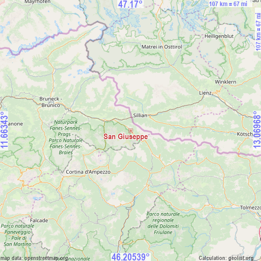
San Giuseppe GPS coordinates[2]
46° 41' 23.46" North, 12° 21' 59.58" East
| Map corner | latitude | longitude |
|---|---|---|
| Upper-left | 47.17°, | 11.66343° |
| Center: | 46.68985°, | 12.36655° |
| Lower-right: | 46.20539°, | 13.06968° |
| Map W x H: | 107.3×107.3 km | = 66.7×66.7mi |
| max Lat: | 47.04031° ⇑0.7% North |
| San Giuseppe: | 46.68985° |
| min Lat: | ⇓99.3% South 35.50142° |
| min Long | San Giuseppe | max Long |
| 6.69888° | 12.36655° | 18.48682° |
| W 60.9%⇐ | ⇒39.1% E |
Elevation
Elevation of San Giuseppe is 1343 m = 4406 ft, and this is 1036.3 m = 3400 ft above average elevation for this country.
| Max E: |
2085 m = 6841 ft | 0.7% |
| San Giuseppe | 1343 m 4406 ft | |
| Avg. | 306.7 m = 1006 ft | |
Min E: |
-4 m = -13 ft | 99.3% |
See also: Italy elevation on elevation.city.
Geographical zone
San Giuseppe is located in North temperate zone (between Tropic of Cancer and the Arctic Circle). Distance of this North polar circle is 2209.7 km =1373 mi to North.| Distance of | km | miles | from San Giuseppe |
|---|---|---|---|
| North Pole | 4815.6 | 2992.3 | to North |
| Arctic Circle | 2209.7 | 1373 | to North |
| Tropic Cancer | 2585.5 | 1606.6 | to South |
| Equator | 5191.4 | 3225.8 | to South |


Nearby cities:
15 places around San Giuseppe: (largest is in red/bold)
• Auronzo
15.2 km =9.4 mi,  163°
163°
• Braies
18.1 km =11.2 mi,  280°
280°
• Candide
15.9 km =9.9 mi,  134°
134°
• Danta
18 km =11.2 mi,  139°
139°
• Dobbiaco
11.8 km =7.3 mi,  291°
291°
• Padola
12.9 km =8 mi, 138°
• San Candido
8.2 km =5.1 mi,  305°
305°
• San Martino
17.2 km =10.7 mi,  321°
321°
• San Nicolò Comelico
17.1 km =10.6 mi, 134°
• San Pietro di Cadore
21.3 km =13.2 mi, 127°
• Santo Stefano di Cadore
20.2 km =12.6 mi, 136°
• Sesto
1.9 km =1.2 mi, 316°
• Tesido
21.2 km =13.2 mi, 294°
• Valle di Casies - Gsies
16.7 km =10.4 mi,  301°
301°
• Villabassa
15.7 km =9.8 mi, 289°
Sources, notices
• [Note1] Compared only with cities in Italy existing in our database
• [Src1] Map data: © OpenStreetMap contributors (CC-BY-SA)
• [Src2] Other city data from geonames.org with taken over terms of usage.
• [Src3] Geographical zone / Annual Mean Temperature by Robert A. Rohde @ Wikipedia
