Villatora geodata
Villatora (Veneto) is a populated place; located in Italy in Europe/Rome (GMT+2) time zone. With population of 6,154 people, there are 1599 cities with bigger population in this country. Compared to other cities in Italy, 69.9% of cities are located further ↓South; 55.4% of cities are located further ←West and 95.3% of cities have higher elevation than Villatora. Note1


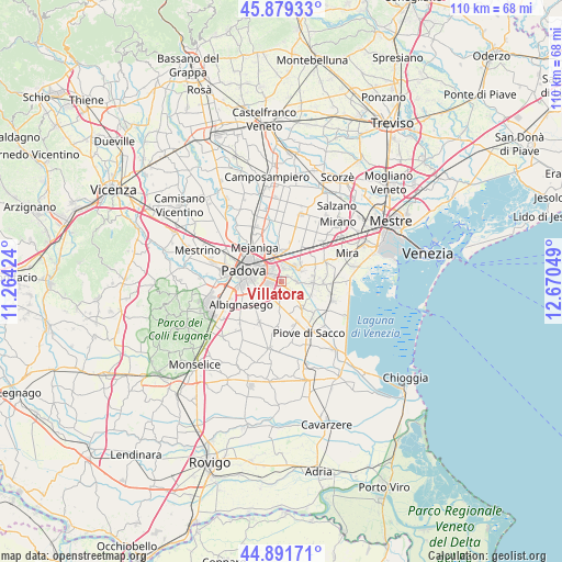
Villatora GPS coordinates[2]
45° 23' 15.648" North, 11° 58' 2.496" East
| Map corner | latitude | longitude |
|---|---|---|
| Upper-left | 45.87933°, | 11.26424° |
| Center: | 45.38768°, | 11.96736° |
| Lower-right: | 44.89171°, | 12.67049° |
| Map W x H: | 109.8×109.8 km | = 68.2×68.2mi |
| max Lat: | 47.04031° ⇑30.1% North |
| Villatora: | 45.38768° |
| min Lat: | ⇓69.9% South 35.50142° |
| min Long | Villatora | max Long |
| 6.69888° | 11.96736° | 18.48682° |
| W 55.4%⇐ | ⇒44.6% E |
Elevation
Elevation of Villatora is 8 m = 26 ft, and this is 298.7 m = 980 ft below average elevation for this country.
| Max E: |
2085 m = 6841 ft | 95.3% |
| Avg. | 306.7 m = 1006 ft | |
| Villatora | 8 m = 26 ft | |
Min E: |
-4 m = -13 ft | 4.7% |
See also: Italy elevation on elevation.city.
Geographical zone
Villatora is located in North temperate zone (between Tropic of Cancer and the Arctic Circle). Distance of this North polar circle is 2354.5 km =1463 mi to North.| Distance of | km | miles | from Villatora |
|---|---|---|---|
| North Pole | 4960.4 | 3082.2 | to North |
| Arctic Circle | 2354.5 | 1463 | to North |
| Tropic Cancer | 2440.7 | 1516.6 | to South |
| Equator | 5046.6 | 3135.8 | to South |


Nearby cities:
15 places around Villatora: (largest is in red/bold)
• Fiesso
6.3 km =3.9 mi,  55°
55°
• Fiesso d'Artico
6.1 km =3.8 mi,  52°
52°
• Fossò
6.2 km =3.9 mi,  91°
91°
• Galta
4.4 km =2.7 mi, 85°
• Legnaro
5 km =3.1 mi,  182°
182°
• Noventa
3.2 km =2 mi,  336°
336°
• Oltre Brenta
3.6 km =2.2 mi,  41°
41°
• Ponte San Nicolò
4.1 km =2.5 mi,  236°
236°
• Roncajette
5.3 km =3.3 mi,  206°
206°
• San Vito
3.5 km =2.2 mi,  353°
353°
• Saonara
2.8 km =1.7 mi,  151°
151°
• Stra
4.5 km =2.8 mi, 54°
• Tombelle
1.7 km =1.1 mi, 43°
• Vigonovo
3.1 km =1.9 mi, 91°
• Vigonza
5.3 km =3.3 mi,  6°
6°
Sources, notices
• [Note1] Compared only with cities in Italy existing in our database
• [Src1] Map data: © OpenStreetMap contributors (CC-BY-SA)
• [Src2] Other city data from geonames.org with taken over terms of usage.
• [Src3] Geographical zone / Annual Mean Temperature by Robert A. Rohde @ Wikipedia
