Cadoneghe geodata
Cadoneghe (Veneto) is a populated place; located in Italy in Europe/Rome (GMT+2) time zone. With population of 3,045 people, there are 3000 cities with bigger population in this country. Compared to other cities in Italy, 71.7% of cities are located further ↓South; 54.9% of cities are located further ←West and 94.1% of cities have higher elevation than Cadoneghe. Note1


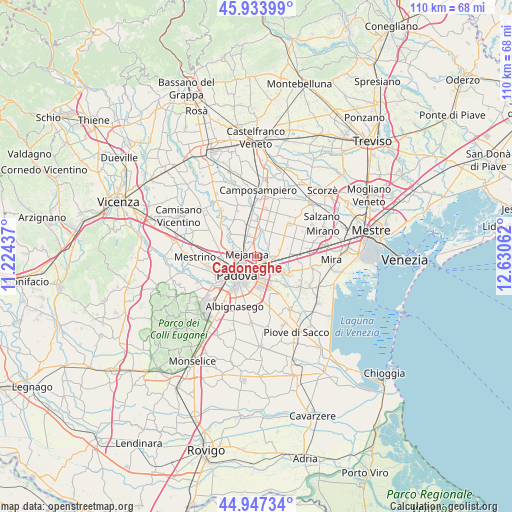
Cadoneghe GPS coordinates[2]
45° 26' 34.152" North, 11° 55' 38.964" East
| Map corner | latitude | longitude |
|---|---|---|
| Upper-left | 45.93399°, | 11.22437° |
| Center: | 45.44282°, | 11.92749° |
| Lower-right: | 44.94734°, | 12.63062° |
| Map W x H: | 109.7×109.7 km | = 68.2×68.2mi |
| max Lat: | 47.04031° ⇑28.3% North |
| Cadoneghe: | 45.44282° |
| min Lat: | ⇓71.7% South 35.50142° |
| min Long | Cadoneghe | max Long |
| 6.69888° | 11.92749° | 18.48682° |
| W 54.9%⇐ | ⇒45.1% E |
Elevation
Elevation of Cadoneghe is 10 m = 33 ft, and this is 296.7 m = 973 ft below average elevation for this country.
| Max E: |
2085 m = 6841 ft | 94.1% |
| Avg. | 306.7 m = 1006 ft | |
| Cadoneghe | 10 m = 33 ft | |
Min E: |
-4 m = -13 ft | 5.9% |
See also: Italy elevation on elevation.city.
Geographical zone
Cadoneghe is located in North temperate zone (between Tropic of Cancer and the Arctic Circle). Distance of this North polar circle is 2348.4 km =1459.2 mi to North.| Distance of | km | miles | from Cadoneghe |
|---|---|---|---|
| North Pole | 4954.3 | 3078.5 | to North |
| Arctic Circle | 2348.4 | 1459.2 | to North |
| Tropic Cancer | 2446.8 | 1520.4 | to South |
| Equator | 5052.8 | 3139.7 | to South |


Nearby cities:
15 places around Cadoneghe: (largest is in red/bold)
• Campodarsego
6.2 km =3.9 mi,  355°
355°
• Codiverno
3.9 km =2.4 mi,  21°
21°
• Mejaniga
2.3 km =1.4 mi,  315°
315°
• Noventa
3.7 km =2.3 mi,  149°
149°
• Oltre Brenta
6.5 km =4 mi,  121°
121°
• Padova
5.1 km =3.2 mi,  219°
219°
• Pianiga
6.4 km =4 mi,  75°
75°
• Pionca
3.7 km =2.3 mi,  46°
46°
• Saletto
6.3 km =3.9 mi,  303°
303°
• San Vito
3.8 km =2.4 mi,  134°
134°
• Terraglione
5.2 km =3.2 mi,  332°
332°
• Tombelle
6.5 km =4 mi,  139°
139°
• Vigodarzere
3.7 km =2.3 mi, 296°
• Vigonza
3.8 km =2.4 mi,  103°
103°
• Villanova
6.3 km =3.9 mi,  35°
35°
Sources, notices
• [Note1] Compared only with cities in Italy existing in our database
• [Src1] Map data: © OpenStreetMap contributors (CC-BY-SA)
• [Src2] Other city data from geonames.org with taken over terms of usage.
• [Src3] Geographical zone / Annual Mean Temperature by Robert A. Rohde @ Wikipedia
