Vigolo geodata
Vigolo (Lombardy) is a seat of a third-order administrative division; located in Italy in Europe/Rome (GMT+2) time zone. With population of 482 people, there are 9987 cities with bigger population in this country. Compared to other cities in Italy, 82% of cities are located further ↓South; 67.5% of cities are located further →East and 84.8% of cities have lower elevation than Vigolo. Note1


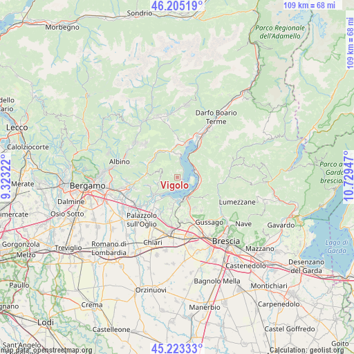
Vigolo GPS coordinates[2]
45° 42' 59.112" North, 10° 1' 34.824" East
| Map corner | latitude | longitude |
|---|---|---|
| Upper-left | 46.20519°, | 9.32322° |
| Center: | 45.71642°, | 10.02634° |
| Lower-right: | 45.22333°, | 10.72947° |
| Map W x H: | 109.2×109.2 km | = 67.9×67.9mi |
| max Lat: | 47.04031° ⇑18% North |
| Vigolo: | 45.71642° |
| min Lat: | ⇓82% South 35.50142° |
| min Long | Vigolo | max Long |
| 6.69888° | 10.02634° | 18.48682° |
| W 32.5%⇐ | ⇒67.5% E |
Elevation
Elevation of Vigolo is 606 m = 1988 ft, and this is 299.3 m = 982 ft above average elevation for this country.
| Max E: |
2085 m = 6841 ft | 15.2% |
| Vigolo | 606 m 1988 ft | |
| Avg. | 306.7 m = 1006 ft | |
Min E: |
-4 m = -13 ft | 84.8% |
See also: Italy elevation on elevation.city.
Geographical zone
Vigolo is located in North temperate zone (between Tropic of Cancer and the Arctic Circle). Distance of this North polar circle is 2318 km =1440.3 mi to North.| Distance of | km | miles | from Vigolo |
|---|---|---|---|
| North Pole | 4923.9 | 3059.6 | to North |
| Arctic Circle | 2318 | 1440.3 | to North |
| Tropic Cancer | 2477.3 | 1539.3 | to South |
| Equator | 5083.2 | 3158.6 | to South |


Nearby cities:
15 places around Vigolo: (largest is in red/bold)
• Adrara San Martino
6.2 km =3.9 mi,  255°
255°
• Adrara San Rocco
5.2 km =3.2 mi,  269°
269°
• Clusane
6.3 km =3.9 mi,  198°
198°
• Fonteno
4.7 km =2.9 mi,  352°
352°
• Iseo
6.7 km =4.2 mi,  163°
163°
• Marone
5.9 km =3.7 mi,  66°
66°
• Parzanica
2.6 km =1.6 mi,  15°
15°
• Pilzone
6.3 km =3.9 mi,  138°
138°
• Predore
4.1 km =2.5 mi,  194°
194°
• Riva di Solto
6.5 km =4 mi,  8°
8°
• Sale Marasino
6.8 km =4.2 mi,  99°
99°
• Siviano
4.2 km =2.6 mi,  92°
92°
• Sulzano
6.6 km =4.1 mi,  119°
119°
• Tavernola Bergamasca
1.7 km =1.1 mi, 122°
• Viadanica
6.2 km =3.9 mi,  234°
234°
Sources, notices
• [Note1] Compared only with cities in Italy existing in our database
• [Src1] Map data: © OpenStreetMap contributors (CC-BY-SA)
• [Src2] Other city data from geonames.org with taken over terms of usage.
• [Src3] Geographical zone / Annual Mean Temperature by Robert A. Rohde @ Wikipedia
