Predore geodata
Predore (Lombardy) is a seat of a third-order administrative division; located in Italy in Europe/Rome (GMT+2) time zone. With population of 1,845 people, there are 4419 cities with bigger population in this country. Compared to other cities in Italy, 80.3% of cities are located further ↓South; 67.7% of cities are located further →East and 56.2% of cities have higher elevation than Predore. Note1


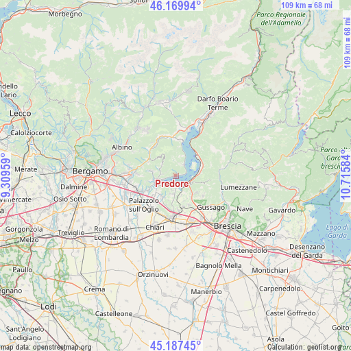
Predore GPS coordinates[2]
45° 40' 51.06" North, 10° 0' 45.756" East
| Map corner | latitude | longitude |
|---|---|---|
| Upper-left | 46.16994°, | 9.30959° |
| Center: | 45.68085°, | 10.01271° |
| Lower-right: | 45.18745°, | 10.71584° |
| Map W x H: | 109.2×109.2 km | = 67.9×67.9mi |
| max Lat: | 47.04031° ⇑19.7% North |
| Predore: | 45.68085° |
| min Lat: | ⇓80.3% South 35.50142° |
| min Long | Predore | max Long |
| 6.69888° | 10.01271° | 18.48682° |
| W 32.3%⇐ | ⇒67.7% E |
Elevation
Elevation of Predore is 194 m = 636 ft, and this is 112.7 m = 370 ft below average elevation for this country.
| Max E: |
2085 m = 6841 ft | 56.2% |
| Avg. | 306.7 m = 1006 ft | |
| Predore | 194 m = 636 ft | |
Min E: |
-4 m = -13 ft | 43.8% |
See also: Italy elevation on elevation.city.
Geographical zone
Predore is located in North temperate zone (between Tropic of Cancer and the Arctic Circle). Distance of this North polar circle is 2321.9 km =1442.8 mi to North.| Distance of | km | miles | from Predore |
|---|---|---|---|
| North Pole | 4927.8 | 3062 | to North |
| Arctic Circle | 2321.9 | 1442.8 | to North |
| Tropic Cancer | 2473.3 | 1536.8 | to South |
| Equator | 5079.2 | 3156.1 | to South |


Nearby cities:
15 places around Predore: (largest is in red/bold)
• Adrara San Martino
5.5 km =3.4 mi,  295°
295°
• Adrara San Rocco
5.7 km =3.5 mi,  312°
312°
• Clusane
2.3 km =1.4 mi,  205°
205°
• Colombaro-Timoline
4.3 km =2.7 mi,  199°
199°
• Corte Franca
6 km =3.7 mi, 198°
• Cremignane
3.5 km =2.2 mi,  173°
173°
• Fontane-Zurane-Gresine
5.9 km =3.7 mi,  153°
153°
• Iseo
3.8 km =2.4 mi,  130°
130°
• Paratico
4.9 km =3 mi,  240°
240°
• Pilzone
5.3 km =3.3 mi,  98°
98°
• Provaglio d'Iseo
5.6 km =3.5 mi, 153°
• Sarnico
4.1 km =2.5 mi,  254°
254°
• Tavernola Bergamasca
3.9 km =2.4 mi,  38°
38°
• Viadanica
4 km =2.5 mi,  276°
276°
• Vigolo
4.1 km =2.5 mi,  14°
14°
Sources, notices
• [Note1] Compared only with cities in Italy existing in our database
• [Src1] Map data: © OpenStreetMap contributors (CC-BY-SA)
• [Src2] Other city data from geonames.org with taken over terms of usage.
• [Src3] Geographical zone / Annual Mean Temperature by Robert A. Rohde @ Wikipedia
