Siviano geodata
Siviano (Lombardy) is a seat of a third-order administrative division; located in Italy in Europe/Rome (GMT+2) time zone. With population of 459 people, there are 10052 cities with bigger population in this country. Compared to other cities in Italy, 81.9% of cities are located further ↓South; 67.1% of cities are located further →East and 54.4% of cities have lower elevation than Siviano. Note1


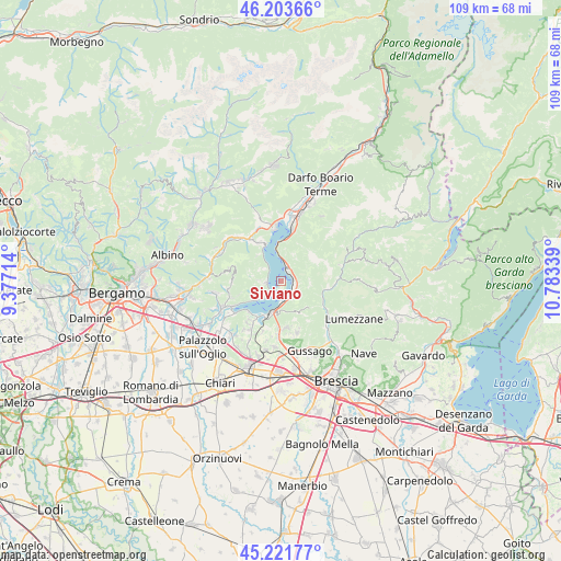
Siviano GPS coordinates[2]
45° 42' 53.532" North, 10° 4' 48.936" East
| Map corner | latitude | longitude |
|---|---|---|
| Upper-left | 46.20366°, | 9.37714° |
| Center: | 45.71487°, | 10.08026° |
| Lower-right: | 45.22177°, | 10.78339° |
| Map W x H: | 109.2×109.2 km | = 67.9×67.9mi |
| max Lat: | 47.04031° ⇑18.1% North |
| Siviano: | 45.71487° |
| min Lat: | ⇓81.9% South 35.50142° |
| min Long | Siviano | max Long |
| 6.69888° | 10.08026° | 18.48682° |
| W 32.9%⇐ | ⇒67.1% E |
Elevation
Elevation of Siviano is 262 m = 860 ft, and this is 44.7 m = 147 ft below average elevation for this country.
| Max E: |
2085 m = 6841 ft | 45.6% |
| Avg. | 306.7 m = 1006 ft | |
| Siviano | 262 m = 860 ft | |
Min E: |
-4 m = -13 ft | 54.4% |
See also: Italy elevation on elevation.city.
Geographical zone
Siviano is located in North temperate zone (between Tropic of Cancer and the Arctic Circle). Distance of this North polar circle is 2318.2 km =1440.5 mi to North.| Distance of | km | miles | from Siviano |
|---|---|---|---|
| North Pole | 4924 | 3059.6 | to North |
| Arctic Circle | 2318.2 | 1440.5 | to North |
| Tropic Cancer | 2477.1 | 1539.2 | to South |
| Equator | 5083 | 3158.4 | to South |


Nearby cities:
15 places around Siviano: (largest is in red/bold)
• Clusane
8.5 km =5.3 mi,  226°
226°
• Fonteno
6.8 km =4.2 mi,  315°
315°
• Gardone Val Trompia
8.6 km =5.3 mi,  107°
107°
• Iseo
6.7 km =4.2 mi,  200°
200°
• Marone
2.8 km =1.7 mi,  25°
25°
• Parzanica
4.4 km =2.7 mi,  307°
307°
• Pilzone
4.6 km =2.9 mi,  179°
179°
• Polaveno
6.8 km =4.2 mi,  150°
150°
• Predore
6.5 km =4 mi, 234°
• Riva di Solto
7.3 km =4.5 mi,  334°
334°
• Sale Marasino
2.7 km =1.7 mi, 110°
• Sulzano
3.4 km =2.1 mi, 153°
• Tavernola Bergamasca
2.9 km =1.8 mi,  255°
255°
• Vigolo
4.2 km =2.6 mi,  272°
272°
• Zone
6.1 km =3.8 mi, 27°
Sources, notices
• [Note1] Compared only with cities in Italy existing in our database
• [Src1] Map data: © OpenStreetMap contributors (CC-BY-SA)
• [Src2] Other city data from geonames.org with taken over terms of usage.
• [Src3] Geographical zone / Annual Mean Temperature by Robert A. Rohde @ Wikipedia
