Bibano geodata
Bibano (Veneto) is a populated place; located in Italy in Europe/Rome (GMT+2) time zone. With population of 1,561 people, there are 4979 cities with bigger population in this country. Compared to other cities in Italy, 89.4% of cities are located further ↓South; 61.7% of cities are located further ←West and 84.1% of cities have higher elevation than Bibano. Note1
Administrative division(s):
- Level 1: Veneto
- Level 2: Provincia di Treviso
- Level 3: Godega di Sant'Urbano


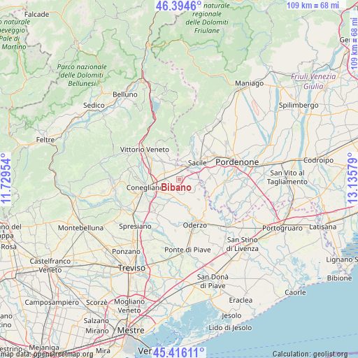
Bibano GPS coordinates[2]
45° 54' 27.036" North, 12° 25' 57.576" East
| Map corner | latitude | longitude |
|---|---|---|
| Upper-left | 46.3946°, | 11.72954° |
| Center: | 45.90751°, | 12.43266° |
| Lower-right: | 45.41611°, | 13.13579° |
| Map W x H: | 108.8×108.8 km | = 67.6×67.6mi |
| max Lat: | 47.04031° ⇑10.6% North |
| Bibano: | 45.90751° |
| min Lat: | ⇓89.4% South 35.50142° |
| min Long | Bibano | max Long |
| 6.69888° | 12.43266° | 18.48682° |
| W 61.7%⇐ | ⇒38.3% E |
Elevation
Elevation of Bibano is 34 m = 112 ft, and this is 272.7 m = 895 ft below average elevation for this country.
| Max E: |
2085 m = 6841 ft | 84.1% |
| Avg. | 306.7 m = 1006 ft | |
| Bibano | 34 m = 112 ft | |
Min E: |
-4 m = -13 ft | 15.9% |
See also: Italy elevation on elevation.city.
Geographical zone
Bibano is located in North temperate zone (between Tropic of Cancer and the Arctic Circle). Distance of this North polar circle is 2296.7 km =1427.1 mi to North.| Distance of | km | miles | from Bibano |
|---|---|---|---|
| North Pole | 4902.6 | 3046.3 | to North |
| Arctic Circle | 2296.7 | 1427.1 | to North |
| Tropic Cancer | 2498.5 | 1552.5 | to South |
| Equator | 5104.4 | 3171.7 | to South |


Nearby cities:
15 places around Bibano: (largest is in red/bold)
• Albina
6.8 km =4.2 mi,  113°
113°
• Cavolano-Schiavoi
5.9 km =3.7 mi,  61°
61°
• Codognè
5.5 km =3.4 mi,  196°
196°
• Cordignano
4.8 km =3 mi,  344°
344°
• Cosniga-Zoppè
6 km =3.7 mi,  248°
248°
• Francenigo
5.5 km =3.4 mi,  89°
89°
• Gaiarine
4.8 km =3 mi,  128°
128°
• Godega
3.6 km =2.2 mi,  310°
310°
• Orsago
2.5 km =1.6 mi,  350°
350°
• Roverbasso
4.2 km =2.6 mi,  155°
155°
• San Fior di Sopra
5.8 km =3.6 mi,  286°
286°
• San Fior di Sotto
4.5 km =2.8 mi,  264°
264°
• San Giovanni di Livenza
6.6 km =4.1 mi,  77°
77°
• San Vendemiano
6.7 km =4.2 mi, 250°
• Villa di Villa
6.7 km =4.2 mi, 348°
Sources, notices
• [Note1] Compared only with cities in Italy existing in our database
• [Src1] Map data: © OpenStreetMap contributors (CC-BY-SA)
• [Src2] Other city data from geonames.org with taken over terms of usage.
• [Src3] Geographical zone / Annual Mean Temperature by Robert A. Rohde @ Wikipedia
