Cosniga-Zoppè geodata
Cosniga-Zoppè (Veneto) is a populated place; located in Italy in Europe/Rome (GMT+2) time zone. With population of 2,456 people, there are 3577 cities with bigger population in this country. Compared to other cities in Italy, 88.8% of cities are located further ↓South; 60.8% of cities are located further ←West and 81.7% of cities have higher elevation than Cosniga-Zoppè. Note1


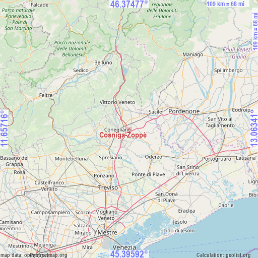
Cosniga-Zoppè GPS coordinates[2]
45° 53' 15" North, 12° 21' 37.008" East
| Map corner | latitude | longitude |
|---|---|---|
| Upper-left | 46.37477°, | 11.65716° |
| Center: | 45.8875°, | 12.36028° |
| Lower-right: | 45.39592°, | 13.06341° |
| Map W x H: | 108.8×108.8 km | = 67.6×67.6mi |
| max Lat: | 47.04031° ⇑11.2% North |
| Cosniga-Zoppè: | 45.8875° |
| min Lat: | ⇓88.8% South 35.50142° |
| min Long | Cosniga-Zoppè | max Long |
| 6.69888° | 12.36028° | 18.48682° |
| W 60.8%⇐ | ⇒39.2% E |
Elevation
Elevation of Cosniga-Zoppè is 43 m = 141 ft, and this is 263.7 m = 865 ft below average elevation for this country.
| Max E: |
2085 m = 6841 ft | 81.7% |
| Avg. | 306.7 m = 1006 ft | |
| Cosniga-Zoppè | 43 m = 141 ft | |
Min E: |
-4 m = -13 ft | 18.3% |
See also: Italy elevation on elevation.city.
Geographical zone
Cosniga-Zoppè is located in North temperate zone (between Tropic of Cancer and the Arctic Circle). Distance of this North polar circle is 2299 km =1428.5 mi to North.| Distance of | km | miles | from Cosniga-Zoppè |
|---|---|---|---|
| North Pole | 4904.9 | 3047.8 | to North |
| Arctic Circle | 2299 | 1428.5 | to North |
| Tropic Cancer | 2496.3 | 1551.1 | to South |
| Equator | 5102.2 | 3170.4 | to South |


Nearby cities:
15 places around Cosniga-Zoppè: (largest is in red/bold)
• Bibano
6 km =3.7 mi,  68°
68°
• Codognè
5.1 km =3.2 mi,  126°
126°
• Colle Umberto
6.3 km =3.9 mi,  347°
347°
• Conegliano
4.5 km =2.8 mi,  270°
270°
• Godega
5.4 km =3.4 mi,  31°
31°
• Mareno di Piave
5 km =3.1 mi,  201°
201°
• Moro
6.4 km =4 mi,  288°
288°
• Saccon
1.7 km =1.1 mi,  208°
208°
• San Fior di Sopra
3.9 km =2.4 mi,  1°
1°
• San Fior di Sotto
2.1 km =1.3 mi, 32°
• San Martino
2.7 km =1.7 mi,  327°
327°
• San Vendemiano
0.7 km =0.4 mi, 268°
• San Vendemiano-Fossamerlo
2.4 km =1.5 mi,  281°
281°
• Santa Lucia di Piave
5.9 km =3.7 mi,  240°
240°
• Vazzola
6.9 km =4.3 mi,  147°
147°
Sources, notices
• [Note1] Compared only with cities in Italy existing in our database
• [Src1] Map data: © OpenStreetMap contributors (CC-BY-SA)
• [Src2] Other city data from geonames.org with taken over terms of usage.
• [Src3] Geographical zone / Annual Mean Temperature by Robert A. Rohde @ Wikipedia
