Fanzolo geodata
Fanzolo (Veneto) is a populated place; located in Italy in Europe/Rome (GMT+2) time zone. With population of 1,562 people, there are 4977 cities with bigger population in this country. Compared to other cities in Italy, 81.8% of cities are located further ↓South; 55.8% of cities are located further ←West and 77.9% of cities have higher elevation than Fanzolo. Note1


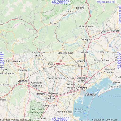
Fanzolo GPS coordinates[2]
45° 42' 43.848" North, 11° 59' 24.828" East
| Map corner | latitude | longitude |
|---|---|---|
| Upper-left | 46.20099°, | 11.28711° |
| Center: | 45.71218°, | 11.99023° |
| Lower-right: | 45.21906°, | 12.69336° |
| Map W x H: | 109.2×109.2 km | = 67.9×67.9mi |
| max Lat: | 47.04031° ⇑18.2% North |
| Fanzolo: | 45.71218° |
| min Lat: | ⇓81.8% South 35.50142° |
| min Long | Fanzolo | max Long |
| 6.69888° | 11.99023° | 18.48682° |
| W 55.8%⇐ | ⇒44.2% E |
Elevation
Elevation of Fanzolo is 60 m = 197 ft, and this is 246.7 m = 809 ft below average elevation for this country.
| Max E: |
2085 m = 6841 ft | 77.9% |
| Avg. | 306.7 m = 1006 ft | |
| Fanzolo | 60 m = 197 ft | |
Min E: |
-4 m = -13 ft | 22.1% |
See also: Italy elevation on elevation.city.
Geographical zone
Fanzolo is located in North temperate zone (between Tropic of Cancer and the Arctic Circle). Distance of this North polar circle is 2318.5 km =1440.6 mi to North.| Distance of | km | miles | from Fanzolo |
|---|---|---|---|
| North Pole | 4924.3 | 3059.8 | to North |
| Arctic Circle | 2318.5 | 1440.6 | to North |
| Tropic Cancer | 2476.8 | 1539 | to South |
| Equator | 5082.7 | 3158.2 | to South |


Nearby cities:
15 places around Fanzolo: (largest is in red/bold)
• Albaredo
5.2 km =3.2 mi,  162°
162°
• Altivole
5.3 km =3.3 mi,  330°
330°
• Barcon
2 km =1.2 mi,  58°
58°
• Busta
3.9 km =2.4 mi,  12°
12°
• Carpenedo
6.6 km =4.1 mi,  128°
128°
• Casacorba
7 km =4.3 mi,  147°
147°
• Caselle
4.2 km =2.6 mi,  349°
349°
• Castelfranco Veneto
6.6 km =4.1 mi,  227°
227°
• Cavasagra
7.5 km =4.7 mi,  137°
137°
• Fossalunga
5.4 km =3.4 mi,  115°
115°
• Riese Pio X
5.9 km =3.7 mi,  288°
288°
• Salvatronda
4.3 km =2.7 mi,  193°
193°
• Trevignano
6.6 km =4.1 mi,  65°
65°
• Vallà
4.5 km =2.8 mi,  262°
262°
• Vedelago
3.5 km =2.2 mi, 141°
Sources, notices
• [Note1] Compared only with cities in Italy existing in our database
• [Src1] Map data: © OpenStreetMap contributors (CC-BY-SA)
• [Src2] Other city data from geonames.org with taken over terms of usage.
• [Src3] Geographical zone / Annual Mean Temperature by Robert A. Rohde @ Wikipedia
