Salvatronda geodata
Salvatronda (Veneto) is a populated place; located in Italy in Europe/Rome (GMT+2) time zone. With population of 2,023 people, there are 4118 cities with bigger population in this country. Compared to other cities in Italy, 80% of cities are located further ↓South; 55.6% of cities are located further ←West and 83.4% of cities have higher elevation than Salvatronda. Note1
Administrative division(s):
- Level 1: Veneto
- Level 2: Provincia di Treviso
- Level 3: Castelfranco Veneto


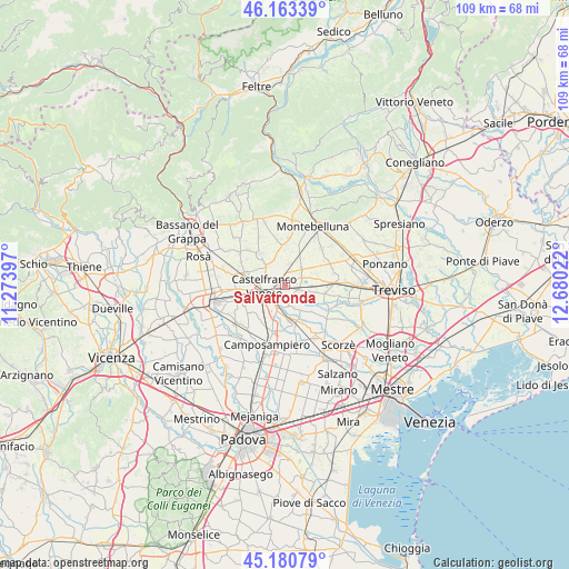
Salvatronda GPS coordinates[2]
45° 40' 27.3" North, 11° 58' 37.524" East
| Map corner | latitude | longitude |
|---|---|---|
| Upper-left | 46.16339°, | 11.27397° |
| Center: | 45.67425°, | 11.97709° |
| Lower-right: | 45.18079°, | 12.68022° |
| Map W x H: | 109.3×109.3 km | = 67.9×67.9mi |
| max Lat: | 47.04031° ⇑20% North |
| Salvatronda: | 45.67425° |
| min Lat: | ⇓80% South 35.50142° |
| min Long | Salvatronda | max Long |
| 6.69888° | 11.97709° | 18.48682° |
| W 55.6%⇐ | ⇒44.4% E |
Elevation
Elevation of Salvatronda is 36 m = 118 ft, and this is 270.7 m = 888 ft below average elevation for this country.
| Max E: |
2085 m = 6841 ft | 83.4% |
| Avg. | 306.7 m = 1006 ft | |
| Salvatronda | 36 m = 118 ft | |
Min E: |
-4 m = -13 ft | 16.6% |
See also: Italy elevation on elevation.city.
Geographical zone
Salvatronda is located in North temperate zone (between Tropic of Cancer and the Arctic Circle). Distance of this North polar circle is 2322.7 km =1443.3 mi to North.| Distance of | km | miles | from Salvatronda |
|---|---|---|---|
| North Pole | 4928.6 | 3062.5 | to North |
| Arctic Circle | 2322.7 | 1443.3 | to North |
| Tropic Cancer | 2472.6 | 1536.4 | to South |
| Equator | 5078.5 | 3155.6 | to South |


Nearby cities:
15 places around Salvatronda: (largest is in red/bold)
• Albaredo
2.7 km =1.7 mi,  106°
106°
• Barcon
6 km =3.7 mi,  27°
27°
• Carpenedo
6.2 km =3.9 mi,  88°
88°
• Casacorba
5.1 km =3.2 mi, 108°
• Castelfranco Veneto
3.9 km =2.4 mi,  265°
265°
• Castelminio
3.4 km =2.1 mi,  166°
166°
• Cavasagra
6.2 km =3.9 mi,  102°
102°
• Fanzolo
4.3 km =2.7 mi,  13°
13°
• Fossalunga
6.2 km =3.9 mi,  71°
71°
• Resana
4.7 km =2.9 mi,  201°
201°
• Sant'Andrea
7 km =4.3 mi,  243°
243°
• Torreselle
6 km =3.7 mi,  144°
144°
• Vallà
5 km =3.1 mi,  316°
316°
• Vedelago
3.5 km =2.2 mi, 65°
• Villarazzo
5.7 km =3.5 mi,  276°
276°
Sources, notices
• [Note1] Compared only with cities in Italy existing in our database
• [Src1] Map data: © OpenStreetMap contributors (CC-BY-SA)
• [Src2] Other city data from geonames.org with taken over terms of usage.
• [Src3] Geographical zone / Annual Mean Temperature by Robert A. Rohde @ Wikipedia
